 |
||||||
The latest news updates for the 2025 climbing season are posted at the top of this page: Climbing Mt. Fuji (富士山) - Frequently Asked Questions (FAQ) ************* Because it’d been 21 years since I last climbed Mt. Fuji, I joked with my friends that I needed to go back and refresh my data.  And
because the last time I climbed Mt. Fuji, it was with 10 other
foreigner
friends up the main Yoshida Trail which was CRAZY
crowded on that August Saturday night, this time I decided to climb up
Mt.
Fuji's Fujinomiya
Trail
(富士宮登山道). And
because the last time I climbed Mt. Fuji, it was with 10 other
foreigner
friends up the main Yoshida Trail which was CRAZY
crowded on that August Saturday night, this time I decided to climb up
Mt.
Fuji's Fujinomiya
Trail
(富士宮登山道). Another reason I chose the Fujinomiya Trail (富士宮登山道) was that at 2400m above sea level, the Fujinomiya 5th Station (富士宮口五合目) is the highest of the 5th stations, plus the Fujinomiya Trail (富士宮登山道) is the shortest route up Mt. Fuji. This is great for old guys like me. The
Fujinomiya 5th Station (富士宮口五合目) is
the 2nd
most popular and 2nd most developed of the four 5th stations on Mt.
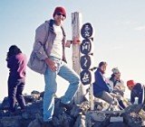
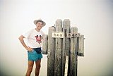
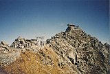
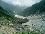
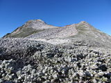
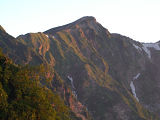
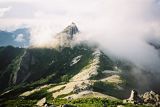
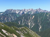
Fuji. Day 1 – August 21, 2012Having spent the night before in a Toyoko Inn near Numazu Station, I started off my Mt. Fuji journey bright and early by catching the 7:30 am Fujikyu bus at Fujinomiya Station, bound for the Fujinomiya 5th Station. After arriving at the Fujinomiya 5th Station (富士宮口五合目) just before 9 am, I milled around a bit to do a little window shopping in the souvenir shop and picked up a free map before hitting the trail at 9:20. There was a very nice gentleman at the trailhead named Nakashima-san who spoke a little English and who gave me another small trail map in English. Well, I couldn't have asked for a nicer day, with the clear blue sky and an absolutely breathtaking view of Suruga Bay all the way up the mountain. On the way up, I met lots of nice folks, and only occasionally did I pass another foreigner. After climbing about an hour or so, I started hearing what sounded like thunder down below, but some other Japanese hikers assured me that it was just live fire drills being conducted by the self-defense forces at Camp Fuji. One of the most interesting things I saw on the way up was the VERY long snowfield known as Mannenyuki (萬年雪), Japanese for "10,000 year snow," which I'm guessing must be at least 200m in length.  Mannenyuki snowfield (萬年雪, 10,000 yr. snow) Alpine Greenery - Another pleasant surprise was to see all the bright green alpine plants above the timberline. One of the most prominent plants that I noticed, especially from the New 7th to the 8th Stations, was the Artemisia Pedunculosa, known in Japanese as Miyamaotokoyomogi (深山男蓬, ミヤマオトコヨモギ), which translates as “deep mountain male sagebrush.” One of my Tokyo friends, who always disparagingly refers to Mt. Fuji as just a pile of cinder and ash, will be very surprised to see my pic of this beautiful green plant in the Flickr album linked below. I was also puzzled by a number of signs at the mountain huts, referring to the Fujinomiya Route as "Omoteguchi." As it turns out, since ancient times, the Fujinomiya Route (富士宮ルート) has been referred to as the "front entrance (表口)" to Mt. Fuji due in part to the way it has been depicted historically in countless poems and literature, as well as artwork such as Katsushika Hokusai's (葛飾 北斎) woodblock print series "Thirty-six Views of Mount Fuji (富嶽三十六景)." I arrived at the Chojo Fujikan summit mountain hut (頂上富士館), my sleeping spot for the night, around 4:15 pm. Before my gorgeous curry rice dinner which was served at 5:00, I had a little time to walk around and check out the Sengentaisha-Okumiya shrine (浅間大社奥宮), the adjoining Fujisan-cho summit post office (富士山頂郵便局), the highest post office in Japan, and the inside of Mt. Fuji’s mountaintop crater (富士山山頂噴火口).  Mt. Fuji summit crater (富士山山頂噴火口) Kengamine (剣ヶ峰), Japan's actual high point - After dinner, I took the 20 min. stroll westward along the Ohachimeguri summit crater loop trail up to the top of Kengamine (剣ヶ峰), elevation 3776m, the highest of Fuji-san’s 8 summit peaks, and the highest point in Japan (日本最高峰). "Ohachimeguri (お鉢めぐり, お鉢巡り)," means in Japanese "to go around the bowl." Click thumbnail below to view detailed trail map for Mt. Fuji's Ohachimeguri:
From the summit of Kengamine (剣ヶ峰), I caught without question one of the most spectacular sunsets I’ve ever seen in my life. As you can see below, the sun set behind a rather extraordinary looking cumulonimbus cloud, with a solid layer of billowy, cumulus clouds below, similar to the view one often sees from the window of a jumbo jet.  Sunset from Mt. Fuji's Kengamine peak At the summit of Kengamine (剣ヶ峰), I found not only a small obelisk marking the highest point in Japan, but also the Mt. Fuji automated weather station (富士山特別地域気象観測所), which was a manned operation for 72 years until September 2004, when it was replaced with a fully automated system. Oops....Crash Landing - Another interesting, but disappointing, thing happened to me atop Kengamine (剣ヶ峰). After a nice Japanese guy took my picture with my camera while I was standing next to the obelisk marking Japan’s high point, I tripped and fell getting down, breaking my digital camera.  Consequently, the rest of the pics and video clips I made on this trip, including the beautiful sunset from Kengamine (剣ヶ峰) and the next morning’s sunrise, were taken with my cell phone. After the beautiful sunset from atop Kengamine (剣ヶ峰) which occurred around 6:30 pm, I needed to get back to the Chojo Fujikan summit mountain hut (頂上富士館) because lights out was at 7:00.  Fuji-san Kengamine sunset with 3-day-old crescent moon Day 2 – August 22, 2012Well, it was rise and shine bright and early at the Chojo Fujikan summit mountain hut (頂上富士館) with lights on at 4:00 am. Of course, SOME eager beavers were already stirring before 3 am. UGH!! Japanese mountain huts are always a tremendous convenience, as they keep you from having to lug in a tent, sleeping bag, cook stove, or a bunch of food, but you can pretty much kiss getting a good night’s sleep goodbye. With all the people snoring, getting up in the middle of the night to go to the toilet, and even talking, earplugs are definitely recommended. And it certainly doesn’t help matters that during peak season, climbers get packed in like sardines, so much so in fact that each person gets less than the width of a normal-size sleeping bag. The Headache from Hell - If all of that wasn’t enough to deal with by itself, I had a head-splitting headache ALL night long. And I was too polite (read: stupid) to get up and track down my aspirin, because I realized it was in the bottom of my pack, which was high up on a shelf, and didn’t want to disturb those who were already sleeping. Big mistake. Not always being the sharpest tool in the shed, I didn’t realize until the next morning that I was in fact for the first time in my life and after nearly a half-century of alpine hiking, suffering from altitude sickness. Duh! In fact when I finally got up, I felt so nauseous that I couldn’t eat my gorgeous rice, seaweed, and furikake (ground seafood flakes, 振り掛け) breakfast prepared by the Chojo Fujikan summit mountain hut (頂上富士館). Instead, I decided to enjoy it later at the 9th station (富士宮九合目) on the way back down. Japanese Sunrise Culture - Well, I must say that viewing the magnificent sunrise (goraiko, 御来光) was a true cultural phenomenon. Just outside of the Chojo Fujikan summit mountain hut (頂上富士館) is a small peak called Komagatake (elev. 3718m), and starting at least 30 min. before sunrise which occurred just after 5 am, climbers with their headlamps started gathering on and around this peak to stake out their spot to view the upcoming sunrise. In those same 30 min. just before sunrise, I would guesstimate that at least five or six tour groups arrived in the summit area from both the Fujinomiya Trail (富士宮登山道) and the Gotemba Trail, which intersects the Ohachimeguri summit loop trail (御鉢めぐり) just immediately to the east from here. By the time 5 am finally rolled around, there were at least 200 people who had gathered to cheer, ooh and aah, and even applaud one of the most breathtaking sunrises I think I’ve ever seen.  Fuji-san sunrise (goraiko, 御来光) at 5:03 am on Aug. 22, 2012 It almost felt religious. Well, why not? After all, Mt. Fuji is not only Japan's highest mountain, but along with Mt. Tateyama and Mt. Hakusan, it is one of Japan's "Three Holy Mountains" (三霊山, Sanreizan). You can catch a small
glimpse of this remarkable Mt. Fuji summit
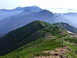
sunrise "busyness" in both my photo album and video below. The Hike Back Down - Because I still wasn’t feeling so hot after the sunrise, I was anxious to get down off the mountain, so I didn’t mill around long before heading down. But in so doing, I passed up a chance to check out the souvenir shop that had opened up inside the Chojo Fujikan summit mountain hut (頂上富士館) and another chance to mail a postcard from the highest post office in Japan. To be honest, I don’t recall ever seeing such a beehive of activity at the early hour of 5:15 AM anytime in my entire life. The 4-hr. trip back down was fairly uneventful (I only slipped and fell twice), and although I stopped
to rest at just about every hut,
even if for only 5 or 10 min., I made it back down to the Fujinomiya
5th Station (富士宮口五合目) in time to catch the first bus back to Shin-Fuji
Station
departing at 9:30 am. Half the fun in making this kind of trip is socializing with the other climbers. At one of my rest stops, I had a friendly chat with a Japanese lady who was hiking with her 2 sons (I shared half of my last apple with them).  Socializing at the Fujinomiya 8th Station (富士宮八合目) rest stop I also had a fascinating visit with a Japanese man in his 70s who was climbing Mt. Fuji all the way up from Suruga Bay and shared with me photos on his iPhone of when he scaled Mt. Whitney in California, the highest peak in the continental 48 U.S. states. After catching a Shinkansen bullet train at Shin-Fuji Station around 11:30, I arrived back at Tokyo Station by around 12:45 and was back in my home by 1:30 pm. It had indeed been a truly remarkable 45 hours. My Mt. Fuji Fujinomiya Trail (富士宮登山道) PicsThe pics in the collage below are a sampling of my Mt. Fuji Fujinomiya Trail (富士宮登山道) photo album hosted at Flickr. Clicking on the collage will open up the 123-pic album's Flickr page. I hope you enjoy them !  Click image above to view all 123 pics in my Mt. Fuji Fujinomiya Trail (富士宮登山道) Flickr album, taken Aug. 21-22, 2012. My Mt. Fuji Fujinomiya Trail (富士宮登山道) Video0:00 Fujinomiya 5th Station (富士宮五合目) 1:13 Fujinomiya trailhead (登山入り口) 1:53 Fujinomiya 6th Station (六合目) 3:31 Fujinomiya New 7th Station (新七合目) 4:50 Fujinomiya Old 7th Station (元祖七合目) 5:11 Fujinomiya 8th Station (八合目) 6:49 Fujinomiya 9th Station (九合目) 7:13 Oxygen can inhalation demo (酸素缶の吸入デモ) 7:23 Mannenyuki (10,000 yr.) snow field (万年雪) 8:37 Fujinomiya 9.5th Station (九号五勺) 9:34 Chojo Fujikan summit mountain hut (頂上富士館) 10:00 Inside Mt. Fuji's crater (山頂噴火口) 11:40 Sunset from Kengamine, Japan's high point (剣ヶ峰(日本最高峰)から日の入り) 12:39 Nighttime climbers with headlamps (ヘッドランプをもっている夜間登山者) 13:45 Sunrise from Mt. Fuji's summit (富士山頂上から日の出) 16:03 The hike down from the summit (頂上から下りにハイキング) 16:22 Returning to Tokyo by Shinkansen bullet train (新幹線で帰京)
My Google Map of Mt. Fuji's
|
 A FREE download at Smashwords  Only $1.99 at Amazon (¥214 at アマゾン日本)  Only $2.99 at Amazon (¥340 at アマゾン日本) Japan Mountain Pages: 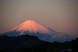 Climbing Mt. Fuji - FAQ 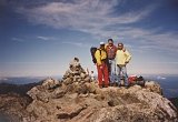 Mt. Kita-dake 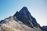 Mt. Oku-hotaka-dake & Mt. Yari-ga-take
|
|||||
|
 Only $2.99 at Amazon (¥343 at ア マゾン日本)  Only 99¢ at Amazon (¥105 at アマゾン日本)  Only 99¢ at Amazon (¥114 at アマゾン日本) What's New?
|
||||||
|
|
||||||