On Sunday, December 5, 2010, I had the pleasure of hiking through the
Yoro Keikoku Valley (養老渓谷) to view the gorgeous fall colors.
The Yoro
Keikoku Valley is one of the most spectacular places to view fall
colors on the Boso Peninsula in Chiba, Japan.
Every year
the local tourism association holds a festival in late November to
celebrate the spectacular fall foliage, where you are certain to see a
wide array of yellow, red, and orange leaves, but primarily the
striking crimson red of the Japanese maple (momiji, もみじ)
trees.
Japanese
maple tree (もみじ)
Route Description
This was my third time to take the Daifukuyama Observatory
(大福山展望台)
/Umegase Canyon (梅ヶ瀬渓谷) hiking course, which I think is the
most
popular route in the Yoro Keikoku area.
From Yoro Keikaku Station (養老渓谷駅)
you'll walk a few minutes
down a very
pretty little path lined by maple trees before crossing the single
train track of the Kominato Line (小湊鉄道線). On the other side
of the
train track, the road curves right and then you'll take the first left
and walk down to cross the beautiful red Hoei Bridge (宝衛橋).
Yoro Keikoku
Valley Hiking Map (a larger area wide map can be viewed here)
From this bridge is a breathtaking view down to the Yoro River
(養老川) in
both directions.
After a couple more kilometers and a short distance after passing
through a tunnel, there will be a Y in the road. This point is called
Megakura (女ヶ倉), where you can go left or right
up to the
Daifukuyama
Observatory.
For some reason, I've always taken the left fork so that I could hike
through the Umegase Canyon first.
After what seems like forever, the road finally ends and you no longer
have to contend with passing cars, and where a real hiking trail begins
in earnest right before you enter Umegase Canyon.
The trail crosses the little stream back and forth a number of times
where you can test your balance by stepping on strategically located
stones which will keep your feet dry.
The scenery through here is breathtaking, especially if you catch the
fall colors at their peak.
And my friend and I were treated to a rather unique waterfall with
little green drops of water which resembled little green twinkly
lights you might see on a Xmas tree. I was able to capture a short
video of it, which is shown
below.
Green Drop Waterfalls,
Umegase
Canyon, Yoro Keikoku Valley
(if unable to
view above, click
here to view on separate page)
After hiking through the Umegase Canyon, about 45 min. or so, you want
to take a steep trail that branches off into the forest on the right
side. This section of the trail is the most difficult along the entire
route, and will be a fairly good workout for beginners, as it was for
my friend that day.
It should take at least 45 min. to get up to the paved road where there
is a small picnic area with tables, a monument, and sometimes even food
and drink vendors. Great place for lunch.
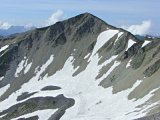
And just a few minutes down the road are the stairs that'll take you up
to the Daifukuyama Observatory tower. The panorama view from there at
elevation 285m is arguably one of the best you'll ever see of the
beautiful greenery of the Boso Peninsula.
View from
Daifukuyama Observatory (大福山展望台)
From the Daifukuyama Observatory back to Yoro Keikoku Station, you'll
be hiking on a paved road, but you'll see some of the most brilliant
red maple leaves anywhere on this course. From the observatory to the
station, it should take you about an hour and 15 minutes. From Megakura
(the fork in the road), it's the same route that you took previously
when hiking from the station.
But for a little variety and an alternate course, before you get back
to the Hoei Bridge, there's a small little street (not so clearly
marked) branching off to the left that will take you across the
brightly blue-painted Keikoku Bridge, which also has a fantastic view
down to the Yoro River as well as of the brightly red-painted Hoei
Bridge which you crossed previously. This scenic alternate route is
less traveled and won't add much extra time to your hike.
Here's a summary of the above-described Daifukuyama Observatory/Umegase
Canyon hiking course (12.1km, ~4 hrs.):
Click here to view all of
my Yoro
Keikoku Valley pics.
I hope you enjoy them !
Access
Hiking courses in the Yoro Keikoku Valley can be accessed via Yoro
Keikoku Station on the single-track Kominato Line. It takes a little
over 2 hours and costs 2170 yen from Tokyo Station to Yoro Keikoku
Station, as of Dec. 2010.
Here is a sample train schedule for a Saturday morning:
Leave Tokyo (東京) @ 8:21am
via JR Keiyo Line
(京葉線) express
train (快速) for Soga (蘇我)
Arrive Soga (蘇我) @ 9:02am
Leave Soga (蘇我) @ 9:05am
via JR Uchibo Line (内房線) local
train
(普通) for Kisarazu (木更津)
Arrive Goi (五井) @ 9:15am
Leave Goi (五井) @ 9:22am
via Kominato Line (小湊鉄道) local
train
(普通) for Kazusa-Nakano (上総中野)
Arrive Yoro Keikoku (養老渓谷) @ 10:24am
Finally, I'd be remiss not to mention the numerous hot springs
(onsen, 温泉) in the Yoro
Keikoku area, some of the best in all of Chiba Prefecture. In fact,
after your hike you should relax your aching feet in the free hot
spring footbath at Yoro Keikoku Station. Enjoy !!
Amazing! I don't recall ever seeing anything like this before...
(click link to see mind-blowing video of Japanese woman performing beautiful aerial silks act)
Hikers who aspire to summit Mount Fuji on its most popular trail can expect a “strict” inspection of their clothing and gear at the entry gate for the Yoshida trail, according to Yamanashi prefecture…
If you've found value on
this website,
please consider sending a donation of any amount
to help cover my web hosting expenses. I have intentionally limited ads,
have never used pop-ups, and do not collect email addresses
in order to provide visitors a pleasant, hassle-free experience. Thank
you!
(Please rest assured that when you click
the 'Donate' button,
your transaction will be encrypted and secure.
Your information is safe with PayPal,
one of the largest payment processors on the Internet.)