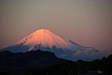
Mt. Hijiri-dake (聖岳),
Japan's 21st
Highest Mountain
"Some call it a
sickness. To swap warm beds for nights on cold granite,
high above the clouds where the air is thin. A willing choice, a desire
even, to leave comfort behind and instead carry your home on your back
through the high places of this world. What else could account for all
this, if not some tragic disease of the mind?"
--Chris White, mountaineer extraordinaire
I couldn't have said it any better, Chris. After trying to retire from
mountain climbing a number of times, I have failed every time. There's
no question it's a mental illness…..and for me, perhaps terminal.

Mt. Hijiri-dake (聖岳) was a very nice, yet rigorous, climb with Naoki,
my
favorite mountain climbing buddy. Naoki is also a former civil
engineer, and used to be my English student at a large Japanese
construction company.
So far, in addition to Mt. Hijiri-dake (聖岳), Naoki and I have together
scaled Mt. Kiso-koma-ga-dake (木曽駒ヶ岳) & Mt. Utsugi-dake (空木岳),
Japan's 25th & 42nd highest peaks, and made 2
attempts at Mt.
Kashimayari-ga-dake (鹿島槍ヶ岳), the 2nd time successfully.
")
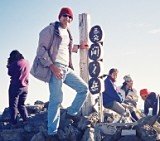
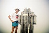
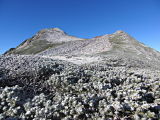
Mountain climbing buddy Naoki atop Mt. Hijiri-dake (聖岳)
Mt. Hijiri-dake (聖岳), elev. 3013m, is not only Japan’s 21st highest
peak, but is also one of the 100 Famous Japanese Mountains (日本百名山,
Nihon Hyaku-meizan). It is also the southernmost of the
"Three-thousanders" (>3000m high peaks) in the Southern (Minami)
Japan Alps (南アルプス).
Day 1 – August 11, 1998
Naoki and I started off by catching a bus before 6 am from JR Shizuoka
Station (JR静岡駅) to the Hatanagi Daiichi (No. 1) Dam (畑薙第一ダム). From
there we transferred to a
microbus that took us to the Tepposeki Bridge (てっぽうせき橋), the trailhead
and
starting point for our hike, also called the Hijiri-dake tozanguchi
(聖岳登山口).
We hit the trail just before 10 am, had lunch shortly after noon, and
arrived at our sleeping spot, the Hijiri-daira-goya
mountain hut
(聖平小屋), just
after 4 pm. My 1995 Yama-to-kogen (山と高原地図) hiking map for Mt.
Hijiri-dake (聖岳) (shown below)
estimates this climb up to
the hut to require 5 hours 40 min. of hiking time, so for us, this was
fairly accurate.
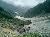
You'll gain over 1100 m along this section of trail, and will cross the
Hijirizawa mountain stream (聖沢) at the Hijirizawatsuribashi suspension
bridge (聖沢吊橋). You'll also pass a scenic overlook
named Takimidai (滝
見台), with a very nice view of a beautiful
waterfall across the valley. There are a
couple pics of us taking a breather there in the photo album
below.
We were pleased with the accommodations at the
Hijiri-daira-goya mountain hut (聖平小屋) where they served a very tasty
curry
rice dinner, and we made a number of friends with the other fellow
hikers.

Curry rice dinner at Hijiri-daira-goya (聖平小屋)
Although curry rice is a popular dish at the mountain huts, good
progress has been made in their menus thru the years. Without question
the best Japan Alps meal I've ever had was a dinner in 2006 at the
Chojo Shukusha mountain hut just below the summit of Mt. Shirouma-dake (白馬岳),
Japan's 26th highest peak, where they even served us buffet style.
Here's a pic of the yum-yum Japanese
cuisine we received at elev. 2730m.
Day 2 – August 12, 1998
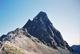
On the second day of hiking, we left the Hijiri-daira-goya mountain hut
(聖平小屋) at 5 am, hiked along the ridge past Mt. Kohijiri-dake (小聖岳), and
were
standing
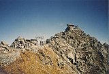
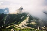
atop Mt.
Hijiri-dake (聖岳), Japan's 21st highest peak, by 7:30. The higher of the
twin Hijiri peaks here is actually known as Mae-hijiri-dake (前聖岳),
elev. 3013m. Too
bad it was so foggy at
the time (Japanese refer to this as "gas"), as I've heard the views
from the summit are stunning. Oh well, next time.
")
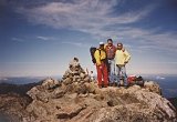
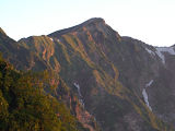
Naoki & I atop Mt. Kohijiri-dake (小聖岳), elev. 2662m
Because the weather wasn't so delightful, we didn't waste a lot of
time hanging around the summit, other than to snap a few pics, and then
retraced our steps back to Hijiri-daira-goya (聖平小屋).
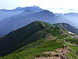
From there we hiked along the ridge to Minami-dake (南岳), elev. 2702m,
and
then
on to Mt. Kamikochi (上河内岳), elev. 2803m, which is one of the 200 Famous
Japanese
Mountains (日本二百名山, Nihon Nihyaku-meizan).
We had a nice relaxing lunch just before 1 pm at the Chausu-goya
mountain hut, then arrived at our sleeping spot for the second night at
the Yokokubosawa-goya
mountain hut (横窪沢小屋) at 3:45 pm. And man oh man,
I can't
tell you how grrrrrreat that can of beer tasted after a 10-hr hiking
day, even if it DID cost ¥400.

Celebrating with a cold one at Yokokubosawa-goya (横窪沢小屋)
There were nice, roomy accommodations there, considering it was during
the Obon
holidays, and in spite of the very vocal snoring chorus during the
night.
Day 3 – August 13, 1998
Our last day in the Minami Alps (南アルプス) was a piece of cake, as it only
took us
3 hours to get down to the Hatanagi Otsurihashi suspension footbridge
(畑薙大吊橋) & trailhead, passing the Usokkozawa-goya mountain hut
(ウソッコ沢小屋) along
the way. The
trail crosses the Kamikochizawa mountain stream (上河内沢) a number of
times, including via the No. 1, No. 2, and No. 3 suspension bridges.
I must say the 182-m-long Hatanagi Otsurihashi bridge (畑薙大吊橋) is a
remarkable
piece of Japanese engineering work, with breathtaking views both up
& down the Oikawa River (大井川) which it crosses. The wooden
plank walkway is only 20-cm wide, has a 15-person load limit, and if
the wind blows while you cross it, will give you an adrenaline rush
comparable to an amusement park ride. Yee hah!
")
Hatanagi Otsurihashi suspension bridge (畑薙大吊橋)
From Hatanagi Otsurihashi (畑薙大吊橋), it took us a little over an hour to
hike
along the road down to the Hatanagi Daiichi (No. 1) Dam (畑薙第一ダム). The
views of
Lake Hatanagiko (畑薙湖) in this area were quite impressive. After downing
a cold beer at the dam, we caught a 3 1/2 hour bus ride back to JR
Shizuoka Station (JR静岡駅).
This was more than enough time for Naoki to fall in love with the cute
bus tour guide girl.
After a quick lunch, we hopped on the
Shinkansen bullet train just before 2 pm, arriving back in Tokyo at
5:30.

Naoki with his new girlfriend, our cute bus tour guide girl
Just kidding, Naoki!
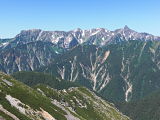
The "Southern" Southern Japan Alps
The southern section of the Southern Japan Alps, of which Mt.
Hijiri-dake (聖岳) is a part, has a special, unique charm of its
own.
As noted by the National Parks of Japan division
of the Ministry of the
Environment:
"Compared
to other peaks belonging to the Minami Alps, Mt.
Kita-dake, Mt. Kaikomagatake, and Mt. Senjogatake in the northern part
of the Minami Alps are marked by relatively short approaches, equipped
with better mountain lodge facilities, and visited by more climbers."
"(On the other hand,) Mt. Hijiri-dake, Mt. Akaishi-dake, Mt.
Arakawa-dake, and other peaks in the southern part of the Minami Alps
are marked by longer approaches and lack mountain lodge facilities that
provide bedding and meals. Accordingly, climbers require greater
physical strength and mountaineering gear to tackle these
mountains."
Well, personally, I’ve never had to use any "gear" in the Japan Alps,
and have never had trouble finding mountain huts, but the relatively
inaccessible nature of the "Southern" Southern Japan Alps is sometimes
a bit of a challenge with bus service in a constant state of change
from year to year, and roads which are constantly being washed out.
And riding in a microbus along some of those mountain road hairpin
curves, that are oftentimes only 1 lane wide, can definitely be a
hair-raising experience.
I believe Paul Hunt, author of "Hiking in
Japan" said it best when he stated in the Minami Alps (南アルプス)
section
of his
book:
"Forestry
tracks and
roads are being pushed further into these remote mountains, but the kami
(gods) often hit back with landslides and floods to destroy men's
efforts. It is my wish that these mountains stay remote, and that the
dedicated hikers and climbers to the peaks carry with them a healthy
respect for the kami
working in these mountains."
My Mt. Hijiri-dake (聖岳) Pics
The thumbnail images below are a sampling of my pics hosted by
Flickr. Clicking the collage opens up my Mt.
Hijiri-dake (聖岳) photo
page
at
Flickr, or you can view
them sequentially in the slideshow player below. I hope
they give you a sense of the exciting,
"back-to-nature" experience
of what it was like to actually be there. Enjoy !
 photo collage")
(View all my Mt. Hijiri-dake (聖岳) pics,
taken
Aug. 11-13, 1998, at a glance here.)
My Google Map of Mt. Hijiri-dake (聖岳)
In Oct. 2009 I created the customized map below, as I thought it'd be
cool to see all of Japan's 25 highest mountains at a glance.
Route Map
for Mt. Hijiri-dake (聖岳)
 (Source: Yama-to-kogen (山と高原地図) hiking map for
Mt.
Hijiri-dake (聖岳))
(Source: Yama-to-kogen (山と高原地図) hiking map for
Mt.
Hijiri-dake (聖岳))
Click here or on image above to
view my full-size 1995
Mt. Hijiri-dake route map. You can order the 2014 version here.
Access
JR Shizuoka Station (JR静岡駅) to Hatanagi Daiichi Dam (畑薙第一ダム): Shizutetsu
Justline Co. (Japanese)
- In 2011, from
7/16 to 8/31, there were 2 buses per day departing JR Shizuoka
Station (JR静岡駅) @ 9:50 & 13:15, and 3 buses per day departing
Hatanagi
Daiichi Dam (畑薙第一ダム) @
14:25, 15:30, & 17:50.
- Cost - ¥3000
- Travel time: 3 hrs. 25 min.
Hatanagi Daiichi Dam (畑薙第一ダム) to Sawara-jima (椹島): Tokai
Forest Co. (Japanese)
- In 2011, from
7/16 to 8/31, there were 5 minibuses per day in each direction, and 3
minibuses
per day at other times between 4/29 and the end of the season in the
fall.
- Cost - free for people staying in the mountain
huts (&
purchasing dinner plus breakfast), also owned & run by the
Tokai
Forest Co. (and in theory, you are not allowed to take these courtesy
minibuses if you are NOT staying in the huts)
- Travel time: 1 hr. (40 min. to the Tepposeki
Bridge (てっぽうせき橋) trailhead)
Note: I've found Google Translate to be a good
resource for translating Japanese webpages into English (and vice
versa).
Please stop by again soon
In summary, climbing Mt.
Hijiri-dake (聖岳) was a rigorous,
yet truly rewarding hiking trip.
While you're in the area, if you've got time, you might as well go
ahead & knock out the nearby Mt.
Warusawa-dake (悪沢岳)and Mt. Akaishi-dake (赤石岳), Japan's 6th
& 7th
highest mountains, only ~5 km away. Why on God's green earth I chose to
climb them all
on separate trips is beyond this aging brain's best recollection.
Please
stop by again soon, as
I hope to update this page in the future on climbing Mt.
Hijiri-dake (聖岳) with more
details, including a record of my hiking schedule & trip
expenses.
In
the meantime, I hope you have a few extra minutes to check out some of
my other pages
on the highest
mountains
in Japan, as well as the rest
of my
website.
Thanks so much for visiting, and if you have any questions for me,
by all means please give me a shout
by using the comment section below or by clicking on the "Contact Me"
link. And I'm sure my readers would love to
hear
your personal story if you've already climbed Mt. Hijiri-dake (聖岳).
But
if this peak is still on your list, I hope you found this page helpful
& I wish you my most heartfelt good
luck. GO
FOR IT
!!
Additional links:
Mt. Hijiri-dake (聖岳) summit 6-day weather
forecast
Mt. Hijiri-dake (聖岳) topo
map (from the Geospatial Information Authority of Japan)
Mt. Hijiri-dake
route map (2023 1:50,000 hiking map, part of the Yama-to-kogen Chizu
series published
by Shobunsha, available in bookstores and from Amazon Japan)
Back
to The Highest Mountains in Japan
|
|