Climbing Mt. Norikura-dake (乗鞍岳), elev. 3026m, Japan's 19th highest
mountain,
in June 1993 was without question one of the most bizarre trips I've
ever made to the top of a Japanese highpoint. Why? Because this
mountain is one of the more popular areas in Japan for
summer skiing (サマースキー), this trip
was more of a ski trip than a mountain climbing venture.
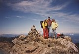
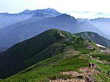
Along with 7
wild & crazy Japanese guys, on Sunday, June 27, 1993 we hiked
w/ ski boots
& poles to the summit and then skied
down.
Climbing up Mt. Norikura-dake (乗鞍岳) hiking trail in ski boots
Ordinarily, this would have been a fairly easy hike, as you only gain a
little over 300m from the Tatamidaira bus terminal (畳平バスターミナル)
& trailhead at elev. 2702m. But I can assure you, there was
nothing "easy" about hiking this course in ski boots.
Being from the HOT, southern U.S. state of Texas, where we don't even
have
one single ski area (actually, we only have few short mountains, and
they’re
out in the deserts of far west Texas), needless to say, my skiing
ability leaves a lot to be desired. As a result, I crashed &
burned a number of times skiing down the peak, providing
quite
a few hearty laughs to the other guys.
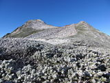
Climbing up Mt. Norikura-dake (乗鞍岳) snow trail
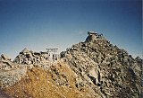
Route Description
From the Tatamidaira bus terminal (畳平バスターミナル), the trail goes around
the south side of the Tsurugaike (鶴ヶ池) pond and along a service road
past Mt. Fujimi-dake (富士見岳), elev. 2817m, and the road that cuts off to
the right & goes over to the summit of Mt. Marishiten-dake
(摩利支天岳), elev.
2872m, where the old Norikura Solar Observatory (乗鞍コロナ観測所) is located.
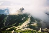
My partners in crime on the service road
enroute to the summit of Mt. Norikura-dake (乗鞍岳)
After a couple of kilometers of fairly level hiking, you’ll reach the
Katanogoya mountain hut (肩の小屋), where the trail coming up from Norikura-kogen (乗鞍高原) ties in.
From the mountain hut, you'll then follow a much steeper hiking trail,
which pretty much parallels the Nagano/Gifu
prefectural boundary, for another kilometer or so up to the summit.
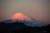
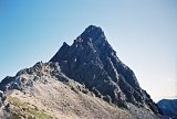
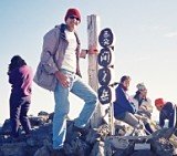
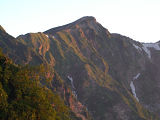
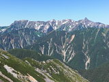
From Mt. Norikura-dake’s actual highpoint, which is called Kengamine
(剣ケ峰), elev. 3026m, the views are truly spectacular in all directions,
including the nearby Kita Alps to the north and the Chuo &
Minami Alps to the southeast. But perhaps the best view is of the lone
wolf Mt. Ontake-san, just a little over 20 km south, which together
with Mt. Fuji are the only 2 of Japan’s 25 highest peaks that are not
part of the 3 Japan Alps mountain ranges.
View from Mt. Norikura-dake (乗鞍岳) summit
From the summit, you can go back down the same way to the Tatamidaira
bus terminal (畳平バスターミナル), or…… just ski down like we did.
My Mt. Norikura-dake (乗鞍岳) Pics
The pics in the collage below are a sampling of my photo
album hosted at Flickr. Clicking on
the collage
will open up the album on a separate page, or you can
view the entire set sequentially in the slideshow player below. I hope
you enjoy them !
Click here to view all of my Mt. Norikura-dake (乗鞍岳)
pics, taken
June 26-27, 1993.
My Google Map of Mt. Norikura-dake (乗鞍岳)
In Oct. 2009 I created the customized map below, as I thought it'd be
cool to see all of Japan's 25 highest mountains at a glance.
Route Map & Elevation Profile
of Mt. Norikura-dake (乗鞍岳)
Note: Mt. Norikura-dake’s actual highpoint is called
Kengamine
(剣ケ峰), elev. 3026m.
(Source: Yamareco.com)
Mt. Norikura-dake (乗鞍岳) Video
Mt. Norikura-dake (乗鞍岳) Access
Because Nagano
Prefectural Highway 84 (長野県道84号乗鞍岳線) (more commonly known as the
Norikura Ecoline (乗鞍エコーライン) road) reaches an elevation of
2710m as it passes thru the Tatamidaira bus terminal (畳平バスターミナル) area,
it
is the highest public road in Japan, and thus is only open from May 15
till Oct. 31 (from the Hirayutoge (平湯峠) gate on the Gifu side to the
Sanbontaki (三本滝) gate on the Nagano side). And in order to protect the
natural
environment, private vehicles have been restricted
year-round since 2003.
So besides the option of hiking up great distances from the lower
elevations, that pretty much limits your access options to shuttle
buses,
taxis, & bicycles to reach the Tatamidaira (畳平) trailhead.
Shuttle bus service to Tatamidaira by the Alpico bus company is
available from various locations including Norikura Kogen Kankou Center
(乗鞍高原観光センター) & Hirayu Onsen (平湯温泉). Route & timetable details
are here. This page shows a Norikura Map and Access Guide from Matsumoto.
The Keio highway bus provides direct service from Shinjuku to Hirayu
Onsen (平湯温泉) (bound for Hida Takayama) and reservations can
be made
online in
English here.
I understand bus service is also available from Matsumoto Station
& Shinshimashima Station, in case you’re coming by train from
Tokyo. I have no details on those, but if anyone has used these bus
services, pls. educate me & I’ll be happy to add the info here.
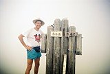
Scenic Takayama City
(高山市)
Since Mt. Norikura-dake (乗鞍岳) is yet another one of Japan's highest
mountains that can
be scaled in a weekend (we didn't leave Tokyo until after 10 pm
Friday night) and we didn't ski down the peak until
Sunday,
we hung out on Saturday in scenic Takayama City
(高山市) in Gifu
Prefecture.
Besides being famous as the closest major city to Mt. Norikura-dake
(乗鞍岳),
Takayama City is also well-known for its carpentry and some of the most
popular Shinto festivals in Japan. These Takayama festivals use
beautifully decorated (and tall!) festival floats, known as “yatais,”
and one of the most interesting things we did that Saturday was to
visit the Takayama Festival Floats Exhibition Hall
(Takayama Matsuri
Yatai Kaikan, 高山祭屋台会館), where these amazingly ornate & colorful
floats are housed.
We also paid a visit and worshiped at the very impressive Sakurayama
Hachimangu Shrine (櫻山八幡宮), which is right across the street from the
festival float hall, a pic of which is in my Flickr photo album above.
And I'd be remiss not to mention the great place we slept Saturday
night, which even had an onsen. Pension Lupinus
is conveniently
located
in the Azumi district of Matsumoto City in Norikura-kogen
(乗鞍高原) right
off the Norikura Ecoline (乗鞍エコーライン) road. Plus, they speak and do email
in
English.
Pension Lupinus
Please stop by again soon
My June 27, 1993 climb of Mt. Norikura-dake (乗鞍岳) with 7 wild &
crazy Japanese
guys was without question one of the most bizarre, yet incredibly fun
mountain climbing trips I've ever made.
Because this trip was still fairly early during my tenure in Japan, it
was a highly instructive cultural lesson in how Japanese
men get
together for a fun weekend & how the innate camaraderie and
team spirit result in a very successful venture.
From the summit of Mt. Norikura-dake (乗鞍岳), the views
of the other several nearby peaks were truly stunning, & some
of the best I've seen anywhere in Japan.
I hope you found this page informative & do please stop by
my site again soon. I also hope you'll take some time to check out some
of the
other Japanese mountain climbing pages, as well as other sections of my
site.
In the meantime, if you have any quick questions for me, or if you'd
care to
share your climbing story or offer some comments for other visitors,
feel free
to do so in the section
below. Thanks for visiting !
Hello Gary, I plan to hike Mt. Oku-hotaka-dake & Mt. Yarigatake in August this year. Maybe I go alone. Can you give some advice what I should prepare for
Hikers who aspire to summit Mount Fuji on its most popular trail can expect a “strict” inspection of their clothing and gear at the entry gate for the Yoshida trail, according to Yamanashi prefecture…
A 51-year-old Dutch national fell while descending Mt. Fuji between the 7th and 8th stations on Saturday, sustaining injuries including a fractured right ankle, police said. The Yoshida Route, the cli…
If you've found value on
this website,
please consider sending a donation of any amount
to help cover my web hosting expenses. I have intentionally limited ads,
have never used pop-ups, and do not collect email addresses
in order to provide visitors a pleasant, hassle-free experience. Thank
you!
(Please rest assured that when you click
the 'Donate' button,
your transaction will be encrypted and secure.
Your information is safe with PayPal,
one of the largest payment processors on the Internet.)