 |
|||||||
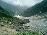
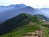
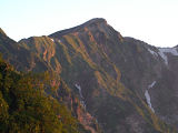
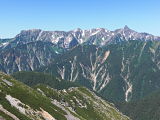
Well, one thing is for certain. My trip to climb Mt. Ai-no-dake (間ノ岳), elev. 3189m, and Mt. Shiomi-dake (塩見岳), elev. 3047m, was by far the LONGEST hike I've ever taken in Japan, both in terms of distance AND time. This 43-km trek on September 14-16, 1996 required 29 hours of hiking over a 2 1/2 day period. Ugh! From the Shiokawa-goya (塩川小屋) mountain hut (elev. ~1350m), my planned western starting point, to Hirogawara (広河原) where I finished my hike, is about 37 km. But when I made this trip, the last segment of road up to Shiokawa-goya (塩川小屋) had been partially washed out and was being reconstructed. As a result, this added an additional 6 km of hiking from where my taxi dropped me off at the Kashio (鹿塩) bus stop. Another noteworthy point about this hiking trip is that it set a personal record for me during my many years of hiking experience in Japan in terms of the net elevation gain. The Kashio (鹿塩) bus stop is at an elevation of approximately 740m, and on my way out I stopped by the summit of Mt. Kita-dake (北岳) (which I had already climbed 3 years prior) at elevation 3192m. This means that from the low point to the high point of this entire hiking trip, I gained over 2400m. This is only remarkable in the sense that for most of Japan's highest mountains, you usually gain in the neighborhood of between 1500-1800m of net elevation gain from the trailhead to the summit. In the case of climbing Mt. Fuji (富士山), from the Fifth Station (2305m) of the main Kawaguchiko (河口湖) trail to the summit (3776m), you gain nearly 1500m. Both Mt. Ai-no-dake (間ノ岳) and Mt. Shiomi-dake (塩見岳) are one of the 100 Famous Japanese Mountains (日本百名山, Nihon Hyaku-meizan). Day 1 – September 14, 1996I spent most of the first day getting to my starting point from Tokyo. From Shinjuku Station, it takes about 4 1/2 hours on the JR Super Azusa express train to Ina-Oshima (伊那大島) Station (the nearest station to the Shiokawa trailhead), changing at Okaya Station (岡谷駅) onto the JR Iida Line (飯田線). After arriving at Ina-Oshima (伊那大島) Station, because I didn't want to wait two hours for the next bus, I decided to splurge for a taxi. As a result, I didn't start hiking till around 2:30 PM and decided to spend the night at the Shiokawa-goya (塩川小屋) mountain hut, a small but nice and reasonably priced place to sleep. In those short 2 1/2 hours of hiking, though, I managed to gain a striking 640 m of elevation up to the hut. Wow. Day 2 – September 15, 1996After waking up bright and early, as is customary in Japanese mountain huts (forget about sleeping late, even if you want to), I had a nice breakfast and set out just before 5 AM. About four hours from the Shiokawa-goya (塩川小屋) mountain hut, you reach Sanpuku-toge (三伏峠), elev. 2615m, a very prominent landmark in Minami Alps National Park (南アルプス国立公園), as it's the highest mountain pass in Japan. One nice thing about this hiking trip was that I was blessed with wonderful weather, drenched in sunshine every day, as you can see in my pics below. Hiking in September can be a bit risky though, with the usual onslaught of typhoons that hit Japan every year during this month. Also, on this trip I didn't run into a lot of fog up in the higher elevations (Japanese climbers call it "gas"), as is customary in the Japan Alps. It was so nice and warm this day, by the time I reached the summit of Mt. Shiomi-dake (塩見岳) just before 1:30 PM, I was hiking in shorts and a T-shirt.  Mt. Shiomi-dake, elev. 3047m, Japan's 16th highest mountain Not far before reaching the summit of Mt. Shiomi-dake (塩見岳), you'll pass the Shiomi-goya (塩見小屋) mountain hut, which I've heard has had some issues with their toilet in years past. I just kept on trekking for the rest of the afternoon, briefly passing the summit of Mt. Kita-Arakawa-dake (北荒川岳), elev. 2698m, before retiring for the night around 7 PM at the unattended, Kuma-no-daira-goya (熊の平小屋) mountain hut (elev. 2650m), which had already closed for the season. I don't recall ever sleeping overnight in an entirely empty building, but I don't believe in ghosts, so I was okay.  Besides me, there were only
two other guys sleeping (snoring) there that night.
Besides me, there were only
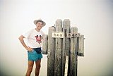
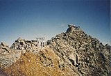
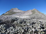
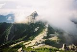
two other guys sleeping (snoring) there that night. Well, it had been a wonderful day of hiking, and little did I know when it started that when I finished, 21 km and 14 hours later, it would go down in history as my longest day of trekking ever in the Japan Alps. But fortunately, unlike the roller coaster ride I experienced climbing Mt. Yakushi-dake (薬師岳), there were not an inordinate number of ups and downs along this route. Day 3 – September 16, 1996I got a nice early start on Diez y Seis de Septiembre (Mexican Independence Day), in fact, hitting the trail just after 3:30 AM. One motivating factor for me to leave so early is that this was the final day of my trip and I was hoping to sleep in my own Tokyo bed that night. Although it was quite frigid that morning, by six o'clock I was atop Mt. Mibu-dake (三峰岳), elev. 2999m, which is a very interesting landmark.  Mt. Mibu-dake, elev. 2999m, Southern Japan Alps Mt. Mibu-dake (三峰岳) lies at the intersection of Shizuoka, Nagano, and Yamanashi Prefectures, meaning you can simultaneously place your hands and feet in three different prefectures. Being a true child at heart, I actually got quite thrilled about this, and have enjoyed sharing this story countless times through the years with my students and friends. Another place I experienced this same phenomenon was atop Mt. Kumotori-yama (雲取山), elev. 2017m, which is not only the tallest mountain in Tokyo, but it lies at the triple intersection of Tokyo, Saitama, and Yamanashi Prefectures. One special treat I had this beautiful morning was the spectacular layer of clouds at the base of the distant peaks, like the view you sometimes see from airplanes flying above the clouds. The Japanese call this "unkai (雲海)," meaning "sea of clouds." Shortly before 7 AM I arrived at the summit of Mt. Ai-no-dake (間ノ岳), elev. 3189m, the fourth highest mountain in Japan and only 3m lower than nearby Mt. Kita-dake (北岳), the second highest mountain in Japan. Mt. Ai-no-dake is also one of the Shiranesanzan (白根三山, "3 white summits"), along with Mt. Kita-dake and Mt. Notori-dake. The view from the top of Mt. Ai-no-dake (間ノ岳) was truly stunning, where you could see the upper half of Mt. Fuji (富士山), Japan's highest peak, a little more than 50 km (~31 mi) away to the southeast, sticking up from a sea of clouds (please see pics below).  Mt. Ai-no-dake, elev. 3189m, Japan's 4th highest mountain Around 11 o'clock, I arrived at the summit of Mt. Kita-dake (北岳), the second highest mountain in Japan, which I had already climbed 3 years prior, but not before stopping off at the Kita-dake-sanso (北岳山荘), where I called my girlfriend on their pay phone and had a piping hot lunch of curry rice. Man, did that stuff taste WONDERFUL! Because Mt. Kita-dake (北岳) lies in the northern part of the Southern Japan Alps, on a clear day you have what is arguably one of the best panoramas from any summit in Japan. Not only is there Mt. Fuji to the southeast, but you can see Mt. Yatsu-ga-take (八ヶ岳), a mere 35 km (~22 mi) to the northeast, the Central Japan Alps 40 km (~25 mi) to the west, and most of the Northern Japan Alps a little more than 80 km (~50 mi) to the north. My hike down from Mt. Kita-dake (北岳) was fairly uneventful, albeit VERY steep, arriving at Hirogawara (広河原), elev. 1600m, at 4:15 PM, the terminus of my 2 1/2 day hike. I was lucky enough to catch a lift with a fellow Japanese climber down to Kofu Station (甲府駅), and yes, I was able to sleep in my own Tokyo bed that night. My Mt. Ai-no-dake (間ノ岳) and
|
 A FREE download at Smashwords  Only $1.99 at Amazon (¥214 at アマゾン日本)  Only $2.99 at Amazon (¥340 at アマゾン日本)
Japan Mountain Pages: 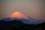 Climbing Mt. Fuji - FAQ 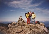 Mt. Kita-dake 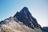 Mt. Oku-hotaka-dake & Mt. Yari-ga-take
|
||||||
|
 Only 99¢ at Amazon (¥114 at アマゾン日本) 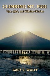 Only $2.99 at Amazon (¥343 at アマゾン日本)  Only $2.99 at Amazon (¥343 at アマゾン日本)
What's New?
|
|||||||
|
|
|||||||