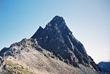
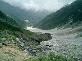
Mt. Suisho-dake (水晶岳) &
Mt. Washiba-dake
(鷲羽岳)
After I climbed Mt. Suisho-dake (水晶岳) & Mt. Washiba-dake (鷲羽岳),
I retired
from mountain climbing. Actually, I do that EVERY year after coming
down from the mountains.  I'm
always in so much pain, I ask myself if
it's all really worth it. I'm
always in so much pain, I ask myself if
it's all really worth it.
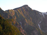
But Mt. Suisho-dake (水晶岳, elev. 2986m) & Mt. Washiba-dake (鷲羽岳,
elev. 2924.2m), Japan's
23rd & 29th highest mountains, were
different. The
night I stayed in the Suisho-goya mountain hut (水晶小屋), a typhoon was
blowing
past the Japanese archipelago off the coast of the Japan Sea. Even
though we were hundreds of kilometers away, with all the severe wind
and rain that night, I honestly felt like that tiny little hut that
sleeps only 30 was going to blow away.
Things were still pretty radical the next morning and if I'd had any
sense, I would've just parked it for a while. But instead, I insisted I
needed to be on my way. Big mistake. The typhoon-force winds almost
blew me off the trail on at least 2 occasions along a precarious
knife-edged ridge on my way back down to Takase Dam, my starting and
ending points for this hike.
Fortunately, my guardian angels kicked it into high gear and I got off
the mountain safely. But during the next several months, I did some
serious soul searching about the benefits vs. costs of this alpine
hobby of mine. So much in fact that I didn't even go back up into the
high country for 2 years.
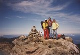
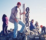
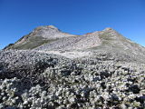
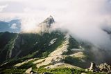
 Atop Mt.
Suisho-dake (水晶岳),
Atop Mt.
Suisho-dake (水晶岳),
elev. 2986 m, Japan's 23rd highest mountain
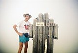
One of the harsh lessons that I learned from that terrifying experience
of coming down from Suisho-goya (水晶小屋) was that I also needed to
re-think my
hiking attire. Back then I was using fairly cheap and relatively
ineffective rainwear, as you can see above. It was basically just a
ground sheet that converted into a poncho, which I'd been using
forever, going back to almost my Boy
Scout days.
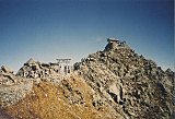
Mt. Suisho-dake (水晶岳) &
Mt. Washiba-dake
(鷲羽岳)
Pics
With the exception of the inclement weather up there on the top, it was
a very beautiful, sunny day when I first started out from Takase Dam
with some rather spectacular panoramas along the way, including that
very special kind of sunset you can only see from the mountains.
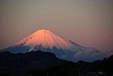
 Sunset near
Mt. Suisho-dake (水晶岳)
Sunset near
Mt. Suisho-dake (水晶岳)
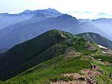
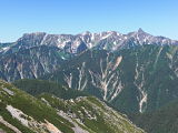
Along the way up to Mt. Suisho-dake, I passed 2 other notable Japan
highpointers in the area, Mt. Noguchi-goro-dake (野口五郎岳, elev.
2924.3m) & Mt. Mitsu-dake (三ツ岳, elev. 2845m),
Japan's 28th
& 47th highest peaks, respectively. And thank God for
the
conveniently located Noguchi-goro-goya (野口五郎小屋) mountain hut, which
practically saved my life because it's where I
sought refuge in the midst of the typhoon rain & winds on my
way back down. Being almost soaked to the bones, I've never had a
more refreshing cup of hot coffee.
And I'd be remiss not to mention the stunning emerald green waters of
Lake Takase, which you can see in my Flickr photo album linked below. I
hope you'll have time to check it out, sit back, and enjoy!!
Yes, when I reflect back on these more beautiful moments of the trip,
it helps balance out in my mind those dangerous moments of when the
typhoon passed.
View the entire
album at a glance here of my pics of Mt.
Suisho-dake (水晶岳) & Mt. Washiba-dake
(鷲羽岳) Japan's 23rd
& 29th
highest peaks, respectively, taken
Aug. 10-12,
2003.
My Google Map of Mt. Suisho-dake (水晶岳) &
Mt. Washiba-dake
(鷲羽岳)
In Oct. 2009 I created the
customized map below, as I thought it'd be
cool to see all of Japan's 25 highest mountains at a glance.
(zoom out to
see all 25 highest mountains)
View 25 Highest
Mountains in Japan in a larger map
Route Map of Mt. Suisho-dake (水晶岳) &
Mt.
Washiba-dake
(鷲羽岳)
Source: Yamareco.com
(Please note: the above route map and elevation profile
differ from my own route, as that course goes all the way to
Shin-Hotaka Onsen. I also started at Takase Dam, but climbed
only Mt. Suisho-dake & Mt. Washiba-dake on this trip.
Couplet Mountains
For 19 years I've been methodically, albeit at an approximate
once-a-year snail's pace, trying to climb the 25 highest mountains
in
Japan. So it's always a pleasure when you can save time by
scaling 2
(or more) peaks from the list on the same trip. Mt. Suisho-dake (水晶岳)
&
Mt.
Washiba-dake (鷲羽岳) were 2 of these what I've termed "couplet
mountains."
Here's a
list of the couplets among the highest mountains in Japan that you can
climb together:
* Actually, these couplet peaks are just the 2 highest among 8 of
Japan's 25
highest mountains that you'll scale on this route.
** You'll also scale another Japan highpointer along
this Warusawa/Akaishi route: Mt. Arakawa-naka-dake, Japan's
13th highest peak. And if you have a little extra time to
kill, Mt.
Hijiri-dake, Japan's 21st highest peak is less than
5 km south of
Mt. Akaishi-dake.
Thank you so much for visiting my
website. If you have an interest in my hiking times and trip costs,
I've
compiled a special page for that: Mt.
Suisho-dake (水晶岳) & Mt. Washiba-dake
(鷲羽岳) Schedule & Expenses
Please come back again soon as I
intend to add more data in
the future.
And if you're the high-tech type, you can subscribe to my RSS feed and
that way you’ll know
when this page is updated.
If you have any questions
or comments, feel free to give me a holler by posting them
in the section below or by clicking on "Contact
Me" in the upper right corner of this page.
And if you've already climbed Mt. Suisho-dake (水晶岳) or Mt. Washiba-dake
(鷲羽岳) & you'd care to pay it forward by sharing your
climbing story & pics with other climbers, we'd love to hear of
your personal experience. You can share your story here.
Additional links:
Mt. Washiba-dake (鷲羽岳) summit 6-day weather
forecast
Mt. Suisho-dake (水晶岳) topo
map (from the Geospatial Information Authority of Japan)
Mt. Washiba-dake
(鷲羽岳) topo
map (from the Geospatial Information Authority of Japan)
Mt. Tateyama/Mt.
Tsurugi-dake
route map (includes Mt. Suisho-dake (水晶岳) and Mt. Washiba-dake
(鷲羽岳) (2023 1:50,000 hiking map part of the Yama-to-kogen Chizu
series published
by Shobunsha)
Back
to The Highest Mountains in Japan
|
|