Mt. Warusawa-dake (悪沢岳)
and
Mt. Akaishi-dake (赤石岳)
Japan's 6th & 7th
Highest Mountains
Mt. Warusawa-dake (悪沢岳), elev. 3141m, and Mt. Akaishi-dake (赤石岳), elev.
3120m, are two peaks on my list
of the 25
highest mountains in Japan which are close enough to be
climbed on the same trip, or what I referred to as "couplet mountains"
on my Mt.
Suisho-dake/Mt. Washiba-dake page.
I had the pleasure of
climbing these two peaks in the Southern Japan Alps (南アルプス), which are
Japan’s 6th & 7th highest mountains, over a 3-day
weekend in August 1995. Both Mt. Warusawa-dake (悪沢岳) and Mt.
Akaishi-dake (赤石岳) are one of
the 100 Famous Japanese Mountains
(日本百名山, Nihon Hyaku-meizan).
A Night in a Coffin
One of my most memorable experiences on this mountain climbing trip was
to sleep Friday night, August 11, 1995 in a coffin-sized room at a
capsule hotel, my first and only such experience in over 20 years of
living in Japan. I must admit it was a very interesting &
pleasant overnight stay.
They had a HUGE public bath and the staff were very cordial and patient
with my very poor Japanese skills (see pic of my
coffin below). My cozy coffin even came equipped with a TV,
reading lamp, radio, nightstand, and an alarm clock.

My Shizuoka City capsule hotel room
The best thing is that it was close enough to JR Shizuoka Station (静岡駅)
that
it was very convenient for me to catch my early morning bus from there
on Saturday morning into the Southern Japan Alps (南アルプス).
2-Phase Bus Transport
On Saturday, August 12, 1995 I caught the first bus from JR Shizuoka
Station (静岡駅) headed for Hatanagi Daiichi Dam (畑薙第一ダム) around 6 AM, as
I recall. This
bus ride takes around 3.5 hours. From the dam you catch a smaller
minibus that will take you to the Sawara-jima (椹島) trailhead in about
an
hour's time.
By the time I finished these two bus rides and completed my backcountry
registration form, it was already late morning before I hit the trail
from my starting point, Sawara-jima (椹島).
With Sawara-jima (椹島) as both the starting and ending points, you can
tackle
Mt. Warusawa-dake (悪沢岳) and Mt. Akaishi-dake (赤石岳) in a loop route. I
chose to
climb Mt. Akaishi-Dake (赤石岳) first, hiking the loop in a clockwise
direction
(please see Yamareco route map below, which follows the same course I
took exactly).
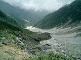
Very Steep & Arduous Ascent
From Sawara-jima (椹島), elev. 1100m, up to the Akaishi-goya mountain hut
(赤石小屋) where I stayed my first night, you'll get a fairly good workout,
gaining around 1400m in only 4.5 km. Wow. (You'll see me celebrating
this achievement with a cold beer in front of the Akaishi-goya (赤石小屋)
in one
of the pics in the Flickr album below.) 
My 17-year-old Yama-to-kogen (山と高原地図)
1:40,000 hiking map for this area shows the hiking time from
Sawara-jima (椹島) up to Akaishi-goya (赤石小屋) to be 5 hrs., which I guess
is still fairly accurate for one in reasonably good shape. In fact,
it’s an over 2000m
elevation gain from Sawara-jima (椹島) to the summits of both Mt.
Warusawa-dake (悪沢岳) & Mt. Akaishi-dake (赤石岳).
This is noteworthy in that to my best recollection, this 2000m
figure is the largest trailhead–to–summit elevation gain that
I've
ever
encountered during the past two decades in scaling any of the 25
highest mountains in Japan. I may of course wind up having to eat my
words later, but I'm going to let this rather bold statement stand for
the time being.
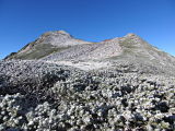
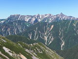
The next day (Sunday, August 13, 1995) was also a fairly rigorous day
of hiking when I managed to scale Mt. Akaishi-dake (赤石岳, elev. 3120m,
Japan's 7th highest peak) and the three
peaks
of Mt. Arakawa-dake (荒川岳), also known as the Arakawasanzan (荒川三
山).
The Arakawasanzan (荒川三
山) include Mt. Mae-dake (前岳); Mt.
Naka-dake (中岳, elev. 3083m, Japan's 13th highest peak and also known as
Mt. Arakawa-naka-dake, 荒川中岳); and one
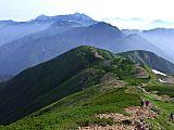
of my main targets for this trip, Mt. Warusawa-dake (悪沢岳), also known
as
Higashi-dake (東岳), elev. 3141m, the 6th highest mountain in Japan.

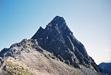
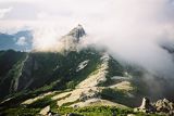
Atop summit of Mt. Warusawa-dake (悪沢岳),
elev. 3141m, the 6th highest mountain in Japan
Sleeping Double in a
Single Bed
I also climbed Mt. Senmai-dake (千枚岳) that day before stopping at the
Senmai-goya
mountain hut (千枚小屋) where I spent the night. Well…… MOST of the night.
This
trip was during the Obon holidays, when most Japanese are given time
off from work (usually 3 days in mid-August) to return to their
hometowns to honor the departed spirits of their ancestors. Thus, it is
a very popular season in Japan for outdoor activities, including
mountain climbing.

Sleeping spaces inside Senmai-goya mountain hut (千枚小屋)
(we had to sleep TWO people per space)
As a result, it was SO crowded at the Senmai-goya mountain hut (千枚小屋),
that
they were sleeping TWO people per usual sleeping space, in an
alternating head–foot/foot–head arrangement. Just my luck that my
sleeping "partner" was an older man who liked to toss and turn in his
sleep. Consequently, by 3:30 AM I had had more than enough of being
kicked in the head by his feet, so I got up quietly and in the darkness
of the hut, packed up my stuff and headed out.
The Pitch-black Haunted Forest
Since it was still nighttime when I started hiking, I had to use a
flashlight to see the trail as I descended through a very thick forest.
This turned out to be a bit of an unnerving experience, in view of not
only the pitch-black darkness of the forest, but
the uncomfortable silence (there was no wind or rustling
leaves),
broken only by the occasional unfamiliar animal-like sounds coming from
behind me.
Let me be clear…..I don’t believe in ghosts, but I'll just come right
out and say it was downright "spooky."
In retrospect, I guess that really wasn’t such a smart thing to do,
especially being by myself, but on the bright side, I was able to get
back down to the Sawara-jima (椹島) trailhead in time to catch the first
morning bus
out @ 6:30 am.
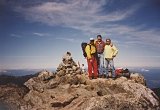
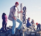
My Hitching Buddies
Another interesting turn in my exciting journey was that when I got
back to Hatanagi Daiichi Dam (畑薙第一ダム), as I recall, there was going to
be at
least a 2-hr. wait for the next bus to JR Shizuoka Station
(静岡駅), so
I hitched a ride with a nice Japanese guy who drove me and a couple of
other hikers back to the station. Very friendly fellas; in fact, we all
enjoyed a nice soba lunch together near the station before parting
ways.

Soba lunch with my hitching buddies
My Mt. Warusawa-dake (悪沢岳) and
Mt.
Akaishi-dake (赤石岳) Pics
The thumbnail images below are a sampling of my pics hosted by
Flickr. Clicking the collage opens up my Mt.
Warusawa-dake (悪沢岳) and Mt. Akaishi-dake (赤石岳) photo
page
at
Flickr. I hope
they give you a sense of the exciting,
"back-to-nature" experience
of what it was like to actually be there. Enjoy !

Mt. Warusawa-dake (悪沢岳) &
Mt.
Akaishi-dake (赤石岳) pics, taken
Aug. 12-14, 1995.
(View all pics at a glance here.)
My Google Map of Mt. Warusawa-dake (悪沢岳) and Mt.
Akaishi-dake (赤石岳)
In Oct. 2009 I created the customized map below, as I thought it'd be
cool to see all of Japan's 25 highest mountains at a glance.
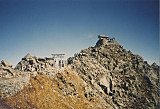
Route Map
& Elevation Profile of Mt.
Warusawa-dake (悪沢岳) & Mt.
Akaishi-dake (赤石岳)
Note: The route above follows my course exactly,
in the clockwise direction. (Source: Yamareco.com)
Access
JR Shizuoka Station (静岡駅) to Hatanagi Daiichi Dam (畑薙第一ダム): Shizutetsu
Justline Co. (Japanese)
- In 2011, from
7/16 to 8/31, there were 2 buses per day departing JR Shizuoka
Station @ 9:50 & 13:15, and 3 buses per day departing Hatanagi
Daiichi Dam @
14:25, 15:30, & 17:50.
- Cost - ¥3000
- Travel time: 3 hrs. 25 min.
Hatanagi Daiichi Dam (畑薙第一ダム) to Sawara-jima (椹島): Tokai
Forest Co. (Japanese)
- From
7/16 to 8/31, 5 minibuses per day in each direction, and 3 minibuses
per day at other times between 4/28 and the end of the season in the
fall
- Cost - free for people staying in the mountain
huts (&
purchasing dinner plus breakfast), also owned & run by the
Tokai
Forest Co. (and in theory, you are not allowed to take these courtesy
minibuses if you are NOT staying in the huts)
- Travel time: 1 hr.
Note: I've found Google Translate to be a good
resource for translating Japanese webpages into English (and vice
versa).
Please stop by again soon
In summary, climbing Mt.
Warusawa-dake (悪沢岳) and Mt. Akaishi-dake (赤石岳) was a rigorous,
yet truly rewarding hiking trip.
To my knowledge, the over 2000m net elevation gain from
trailhead to
summit on this trip is the largest I've ever encountered while scaling
any of the 25 highest mountains in Japan. To be
exact, it's a 2041m vertical gain (6696 ft., or 1.27 vertical miles)
from Sawara-jima (椹島) to the summit
of Mt. Warusawa-dake (悪沢岳). Ouch !
Please
stop by again soon, as
I hope in the future to update this page on climbing Mt.
Warusawa-dake (悪沢岳) and Mt.
Akaishi-dake (赤石岳) with more
details as they become available.
In
the meantime, I hope you have a few extra minutes to check out my pages
on the other highest mountains
in Japan, as well as the rest
of my
website.
Thanks so much for visiting, and if you have any questions for me,
by all means please give me a shout
by clicking on the "Contact Me" link. I would also love to
hear
your personal story if you've already climbed some of these
peaks. But
if
they're still on your list, I wish you my most heartfelt good luck. GO
FOR IT
!!
Additional links:
Mt. Warusawa-dake summit 6-day weather
forecast
Mt. Akaishi-dake summit 6-day weather
forecast
Mt. Warusawa-dake topo
map (from the Geospatial Information Authority of Japan)
Mt. Akaishi-dake topo
map (from the Geospatial Information Authority of Japan)
Mt. Warusawa-dake and Mt.
Akaishi-dake route map (2023 1:50,000 hiking map part of the
Yama-to-kogen Chizu series published by Shobunsha)
Back
to The Highest Mountains in Japan
|
|