Mt. Kiso-koma-ga-take (木曽駒ヶ岳) and
Mt. Utsugi-dake
(空木岳)
Japan's 25th & 42nd Highest Mountains
The awesome peaks of Mt. Kiso-koma-ga-take (木曽駒ヶ岳), elev. 2956m, and
Mt. Utsugi-dake
(空木岳), elev. 2864m, in the Central
Japan Alps (中央アルプス, also referred to as the Chuo Alps) are two of
the couplet
mountains I mentioned on my Mt.
Suisho-dake/Mt. Washiba-dake page that
you can climb in tandem.
In over two decades of hiking in the Japanese high country, this
mountain climbing trip was the only time I’ve ever visited the Central
Japan Alps (中央アルプス). And Mt. Kiso-koma-ga-take (木曽駒ヶ岳) is the only peak
among
Japan’s
highest 25 mountains that is in the Central Japan Alps (中央アルプス).
Although the Central Japan Alps (中央アルプス) are often overshadowed by
their
neighboring sister ranges, the Northern Japan Alps (北アルプス) and the
Southern
Japan Alps (南アルプス), these peaks are awesome in their own right and
deserve a
lot of respect. To tell you the truth, this expedition to climb Mt.
Kiso-koma-ga-dake (木曽駒ヶ岳) and Mt. Utsugi-dake (空木岳) was one of the more
difficult
ones I’ve ever done in Japan.

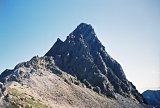
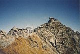
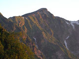
Mt. Kiso-koma-ga-take (木曽駒ヶ岳), as seen from
Mt. Sannosawa (三ノ沢岳) (Photo courtesy: Wikipedia)
I’m not exactly sure why, but I’m guessing that because the trails in
the Central Japan Alps (中央アルプス) do not get nearly the traffic that
trails
in the Northern & Southern
Japan Alps do, and because the design, construction, and
maintenance of these trails are relatively more primitive, negotiating
them requires a lot more effort, with a lot more ups and downs
and a lot more scrambling being necessary.
As a result, the ridge trail between Mt. Kiso-koma-ga-dake (木曽駒ヶ岳) and
Mt.
Utsugi-dake (空木岳) severely kicked my butt. While the Lonely Planet’s “Hiking
in Japan ” guide
estimates the hiking time from Senjojiki (千畳敷) to the
Kisodono-sanso mountain hut (木曽殿山荘) as 6 to 8 hours (including
traversing the
Kiso-koma summit), it took me well over 10. Of course, I may have just
been out of shape. ” guide
estimates the hiking time from Senjojiki (千畳敷) to the
Kisodono-sanso mountain hut (木曽殿山荘) as 6 to 8 hours (including
traversing the
Kiso-koma summit), it took me well over 10. Of course, I may have just
been out of shape.  But word to the wise, I found this ridge trail
above-average in difficulty.
But word to the wise, I found this ridge trail
above-average in difficulty.
Of course, if you’re just interested in climbing Mt. Kiso-koma-ga-dake
(木曽駒ヶ岳) as a day hike, the convenient Chuo
Alps Komagatake Ropeway
(駒ヶ岳ロープウェイ) shaves
950m off the vertical ascent, leaving only a little over 300 more
vertical meters from the top of the ropeway to the summit of Mt.
Kiso-koma-ga-dake (木曽駒ヶ岳). Nice.
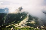
And if you’re rich, you might just want to stay overnight in the
gorgeous Senjojiki Hotel (ホテル千畳敷) at the top of the ropeway, which we
had very nice views of from up above on the ridge trail.

Senjojiki Hotel (ホテル千畳敷) &
upper terminus of Komagatake ropeway (駒ヶ岳ロープウェイ)
Day 1– August 12, 2002
My favorite hiking buddy, Naoki, and I left Shinjuku bright and early
this Saturday morning at 7 am on a bus for the city of Komagane (駒ヶ根),
where
we caught another bus at 11:30 for Shirabi-daira (しらび平), the bottom
terminus
of the ropeway.
Because it was a busy summer weekend, coinciding with the Japanese Obon
holiday season, we had to wait around a couple of hours before catching
the ropeway up to Senjojiki (千畳敷) at 2:15 pm.
But it was kind of fun just milling around the many sightseeing
tourists, as this beautiful area is part of the Nagano Prefectural
Nature Park (長野県立自然公園).

Speaking of nature, hiking in the
Central Japan Alps has its fringe benefits.
After the short 8-min. ropeway ride, we hiked up to our sleeping spot
for the night, the Chojo-sanso
mountain hut
(頂上山荘, Japanese for "Summit
Hut"), which is just below the
summit of Mt. Kiso-koma-ga-dake (木曽駒ヶ岳), arriving there at 3:50 pm.
Day 2 – August 13, 2002
The next morning we got a nice early start, leaving our packs at the
mountain hut since we would be coming back the same way, and arrived at
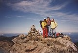
the summit of Mt. Kiso-koma-ga-dake (木曽駒ヶ岳) at 6:35 am, only a 15 min.
hike
from the mountain hut. It was fortunately a nice sunny day, so we were
able to take quite a few nice snapshots.
Back at the Chojo-sanso mountain hut (頂上山荘), we took a little time to
do some
last-minute packing and then hit the trail around 7:30, headed for
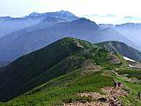
Hoken-dake (宝剣岳). Hoken-dake (宝剣岳) is an interesting little outcropping
of granite
rock, which required the built-in chains to negotiate. And the
beautiful sunny weather allowed Naoki and I to snap away with our
cameras. There were truly some stunning views from up there.
")
Hoken-dake (宝剣岳)
Back on
the trail, we headed for Gokuraku-daira, reaching there at 10 o’clock
and passed Dakusawa-omine (濁沢大峰) just after 11 o’clock. We stopped for
our
1-hour lunch at Hinokio-dake (檜尾岳), where Naoki fired up some nice
chicken
soup for us on his propane gas stove.
One of the funniest things that happened to me on this day was when I
lost
my zip-off, detachable day pack. As I recall, this was the first time
for me to use my new JanSport backpack (Believe it or not, I still use
this pack, so it's certainly not new
anymore.).
One of the reasons I had bought
it was that I thought the zip-off day pack feature was pretty cool. The
only thing is, that day I didn’t secure it properly to my backpack, and
with all the jostling back and forth on one of the more primitive
sections of the ridge trail, it finally went flying.
And although Naoki & I both got a good chuckle seeing it tumble
down about 30m off to the side of the trail, I can assure you it was no
fun scrambling down all that loose rock debris on a very steep
talus slope to retrieve it.
I realized later that my wallet and other valuables were
inside
that little day pack. Duh, Gary! Well, let's just say it was a learning
experience.
When we reached Higashikawa-dake (東川岳) shortly after 3:00, we decided
that
Naoki should probably go ahead & hike on ahead by himself and
leave this slowpoke behind. We wanted to notify the Kisodono-sanso
mountain hut (木曽殿山荘), our sleeping spot for the 2nd night,
that we were running a little late, but we had no
cell
phone service up there. So the hare went on and hiked up ahead by
himself, arriving at the mountain hut at least a half-hour before the
tortoise.
The folks at the Kisodono-sanso mountain hut (木曽殿山荘) were exceptionally
cordial
and served up a very hearty and tasty dinner. And before retiring, we
were blessed with an outstanding sunset. Wow.

Sunset from the Kisodono-sanso mountain hut (木曽殿山荘)
Day 3 – August 14, 2002
Well, we woke up this morning and discovered that our gorgeous weather
had gone south. And if the fog...borderline mist...was not enough
(speaking of the ups & downs I mentioned previously), the
Kisodono-sanso mountain hut (木曽殿山荘) sits at an elevation of only 2587m,
which
is actually lower than our starting point on Day 1, elev. 2612 m, at
the top of the ropeway at Senjojiki (千畳敷).
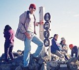
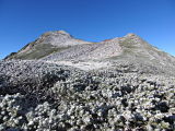
So the very steep and rocky, nearly 300m vertical climb up to the
summit of Mt. Utsugi-dake (空木岳) was without question the most difficult
part
of this entire course. LOTS of chains & LOTS of scrambling. So
I was already wiped out by the time we reached the summit at 7:15 am.
")
Atop Mt. Utsugi-dake (空木岳)
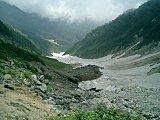
Ordinarily, the 8-km hike down the beautiful Ikeyama-one ridge (池山尾根)
to the Komagane Kogen (駒ヶ根高原) trailhead would’ve been very enjoyable,
but I was
in so much pain when I finished this hike, I officially retired from
mountain climbing. No joke (but I started back again the following
year).
Naoki & I had lunch at the Ikeyama-goya mountain hut (池山小屋) at
11:30, and just before the end of the trail, we had a nice visit with
some fellow climbers who were collecting wild mushrooms & other
mountain vegetables for their sansai soba (山菜そば).
And by far the best part of the entire trip was the Komakusa-no-yu
onsen in Komagane Kogen (駒ヶ根高原) where we soaked our sore
muscles before heading
home. After catching a bus in Komagane (駒ヶ根) City at 4 pm, we arrived
back in
Shinjuku before 9:30. Yee hah!
My Mt. Kiso-koma-ga-take (木曽駒ヶ岳)
and Mt. Utsugi-dake (空木岳)
Pics
The pics in the collage below are a sampling of my Kiso-koma/Utsugi
photo
album hosted at Flickr. Clicking on
the collage
will open up the album on a separate page. I hope
you enjoy them!

Click here to view all of my Mt. Kiso-koma-ga-take
(木曽駒ヶ岳) and Mt. Utsugi-dake (空木岳)
pics, taken
Aug. 12-14, 2002.
My Google Map of Mt. Kiso-koma-ga-take (木
曽駒ヶ岳) and Mt. Utsugi-dake (空木岳)
In Oct. 2009 I created the customized map below, as I thought it'd be
cool to see all of Japan's 25 highest mountains at a glance.
Route Map & Elevation Profile
of Mt. Kiso-koma-ga-take (木曽駒ヶ岳)
and Mt. Utsugi-dake (空木岳)
Access
Depending upon which part of Japan you’re coming from, there are
perhaps an uncountable number of ways to access these gorgeous peaks by
train or bus from both east and west sides of the Central Japan Alps
(中央アルプス)
mountain range. Even from the east side, which is the way I went and
includes the Chuo Alps Komagatake Ropeway, you have many options.
Naoki and I caught a Keio
Dentetsu Bus from their bus
terminal on the west side of JR Shinjuku Station, which took us to the Komagane (駒ヶ根) City bus terminal, denting our
pocketbooks ¥6500 for the
round-trip (as of April 2012, it costs ¥6900). There are 16 buses a
day, making the 4-hour trip in each direction. The Shinjuku to Komagane
bus timetable is here, and the Komagane to Shinjuku
bus timetable is here.
At one time, the Keio Dentetsu Bus Co. also offered a round-trip
ticket from Shinjuku all the way to the top of the ropeway at
Senjojiki for ¥10,000.
The 50-min. bus ride from Komagane (駒ヶ根) to the Shirabi-daira (しらび平)
ropeway
terminus runs every 30 min. (every hour from December through March),
and costs ¥1210 one-way or ¥2000 for the round-trip. The 8-min. ropeway
ride runs every 20 min. and costs ¥1180 one-way or ¥2000 for the
round-trip. Both the bus and ropeway are operated by the Chuo Alps
Kanko Co.
More detailed fare & timetable info for the bus to
Shirabi-daira (しらび平) and the
ropeway to
Senjojiki (千畳敷) can be found here.
Please note that private cars are restricted on the road from the
Suganodai Bus Center to Shirabi-daira (しらび平), so hitchhiking is out of
the
question.
Please stop by again soon
My Aug. 12-14, 2002 climb of Mt. Kiso-koma-ga-take (木曽駒ヶ岳) and Mt.
Utsugi-dake (空木岳) in
the Central Japan Alps (中央アルプス) was an awesome hiking trip. From these
hiking trails, on a clear day the views
of other nearby peaks in both the Northern Japan Alps (北アルプス)
& Southern Japan Alps (南アルプス) will take your breath away.
The only drawback about
hiking during the busy Obon holidays in Japan, though, is you
are certain to encounter crowded conditions on the trails & in
the huts. But I guess that comes with the
territory, because like Golden Week and the New Year's holidays, during
Obon most Japanese tend to all vacation at the same time, making the
trains, planes, and highways pure craziness.
I hope you found this page
informative & do please stop by
again soon, as
I intend to update it in the future with more details on climbing Mt.
Kiso-koma-ga-take (木曽駒ヶ岳) and Mt.
Utsugi-dake (空木岳), including a record of my climbing schedule and
trip expenses.
In the meantime, if you have any quick questions for me, feel free to
give me a shout
by posting them in the "Add your comment" section below or by clicking
on the "Contact Me" link at the top right of this page.
And
if you've already climbed Mt. Kiso-koma-ga-take (木曽駒ヶ岳) or Mt.
Utsugi-dake (空木岳) & you'd
care to
pay it forward & share your climbing story & pics with
other
climbers, we'd love to hear of your personal experience.
You
can share your story here.
If you're lucky enough to
hike up either of these awesome peaks, I wish you my most heartfelt
good
luck. GO FOR IT !!
Additional links:
Mt. Kiso-koma-ga-take (木曽駒ヶ岳) summit
6-day weather forecast
Mt. Utsugi-dake (空木岳) summit
6-day weather forecast
Mt. Kiso-koma-ga-take (木曽駒ヶ岳) topo
map (from the Geospatial Information Authority of Japan)
Mt. Utsugi-dake (空木岳)
topo
map (from the Geospatial Information Authority of Japan)
summit
6-day weather forecast
Mt.
Kiso-koma-ga-take/Mt. Utsugi-dake route map (2023 1:50,000 hiking map,
part of the
Yama-to-kogen Chizu series published
by Shobunsha, available in bookstores and from Amazon Japan)
The Long Dream - A very
gripping story of a failed Dec. '08
winter climb of Mt.
Kiso-koma-ga-dake (木曽駒ヶ岳) by mountaineer extraordinaire Mr. Chris White
The Crucible and the Rate - Another
gripping story of his follow-up successful
Feb. '09
winter climb of Mt.
Kiso-koma-ga-dake (木曽駒ヶ岳) by mountaineer extraordinaire Mr. Chris White
(I just love reading this man's stories, and really think he deserves a
Pulitzer...)
|
|