Mt. Senjo-ga-take (仙丈ヶ岳) and
Mt. Kai-koma-ga-dake
(甲斐駒ヶ岳),
Japan's 18th & 24th Highest Mountains
The awesome peaks of Mt. Senjo-ga-take (仙丈ヶ岳), elev. 3033m, and Mt.
Kai-koma-ga-dake
(甲斐駒ヶ岳), elev. 2967m, in the
northern section of the Southern Japan Alps (南アルプス) are two of
the couplet
mountains I mentioned on my Mt.
Suisho-dake/Mt. Washiba-dake page that
you can climb in tandem.
Although unlike the other couplet peaks among Japan's highest
mountains, the trailhead at Kitazawa-toge (北沢峠) is between the two
peaks, so you have to hike all the way back down to the bottom before
you can hike up to the top of the other one. But they're both pretty
easy, so it doesn't really matter much.
If you're only going to do these two main peaks as I did, rather than
tackling other prominent peaks in the immediate area, such as Mt.
Nokogiri-dake (鋸岳), Mt.
Kita-dake, or Mt. Ho-o-sanzan (鳳凰三山), I'm not
sure
whether there is any particular strategy on which of the two peaks you
do first.

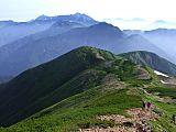
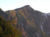
Mt. Senjo-ga-take (仙丈ヶ岳) and its trademark cirque,
as seen from the Mt. Ko-senjo-ga-take (小仙丈ヶ岳) summit
In my case, I chose to climb Mt. Senjo-ga-take (仙丈ヶ岳) first, so I
could stay overnight at the Sensui-goya (仙水小屋) mountain hut,
which is
about 45 min. along the Mt. Kai-koma-ga-dake (甲斐駒ヶ岳) trail
from
the
Kitazawa-toge
(北沢峠) trailhead.
Another option that many hikers choose, is to stay at one of the
mountain huts at or near the Kitazawa-toge (北沢峠) trailhead, including Kitazawa Pass Komorebi Sanso (北沢峠 こもれび山荘), Minami Alps Nagae Hut (南アルプス市長衛小屋),
or Ohira-sanso (大平山荘).
This way you can park your heavy gear at the hut and climb both peaks
with a light day pack.
One of the things I like
best about the Southern Japan Alps
(南アルプス) is their proximity to Tokyo. Mt. Senjo-ga-take (仙丈ヶ岳) and Mt.
Kai-koma-ga-dake
(甲斐駒ヶ岳), the 18th and 24th highest mountains in
Japan, were another set of
peaks that I did in only
two days. During my Obon holidays, I left Shinjuku just before midnight
on Monday, August 11,
1997 and
arrived back in Shinjuku around 6:30 pm two days later on August 13.
Day 1 – Tues. August 12, 1997
After
arriving at JR Kofu Station, I caught a 3:00 am bus for
Hirogawara where after arriving there, I transferred a couple of hours
later @ 6:50 am to a microbus
which drove
me 25 min. to the Kitazawa-toge (北沢峠) trailhead. After hitting the
trail around
7:20
am, the
approximate three-hour trek to the summit of Mt. Senjo-ga-take (仙丈ヶ岳)
was very
pleasant,
where you
first pass through a very dense forest before reaching a fork in the
trail at
Go-go-me (五合目, Fifth Stage), the theoretical halfway point.
The
right fork will take around 30 minutes longer to the Mt. Senjo-ga-take
(仙丈ヶ岳)
summit, but also has three mountain huts along the
way, in case you would need to seek refuge or are looking for a place
to stay. In
ascending order, these mountain huts are Senjo-yabusawa-goya (仙丈薮沢小屋), Uma-no-se-hyutte
(馬の背ヒュッテ, "Horseback Hut"),
and Senjo-goya (仙丈小屋).
In
my case, I chose the left fork, both up and down. By the
time you reach Mt. Ko-senjo-ga-take (小仙丈ヶ岳),
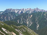
you'll be above the tree line and will have some absolutely stunning
views of
other peaks in the vicinity, including not only nearby Mt.
Kai-koma-ga-dake, but Mt.
Nokogiri-dake (鋸岳), Mt.
Kita-dake (北岳), Mt.
Ai-no-dake (間ノ岳), Mt.
Fuji (富士山), Ho-o-sanzan (鳳凰三山),
and on a clear day, even the Central Japan Alps (中
央アルプス) and Northern
Japan Alps (北
アルプス).
There is also a 3rd trail to the Mt. Senjo-ga-take
(仙丈ヶ岳) summit, starting from near the
Ohira-sanso (小平山荘) mountain hut, which is known as the Yabusawa Route
(薮沢ルート).
After hiking back down to
the Kitazawa-toge (北沢峠) trailhead, I
trekked 45 min. or so over to the Sensui-goya (仙水小屋) mountain
hut, my sleeping spot for
the end of Day 1, arriving there around 3 pm. This
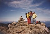
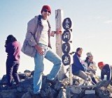
mountain hut was one
of the more interesting parts of my trip, where I easily made many new
friends,
getting lots of special attention from being the only gaijin in the
area.

My new friends @ the Sensui-goya (仙水小屋) mountain hut To be honest, this is one
of the many reasons I enjoy living
in Japan so much. Because here I am frequently made to feel special,
almost
on a
daily basis, I in effect often feel like a big fish in a small pond,
rather
than just a small fish in a big pond…..which is the way
I'm usually treated back in my
home state
of Texas. 
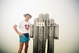
The
Sensui-goya (仙水小屋) mountain hut was pretty small,
sleeping only about 30, but I was impressed with their solar stove, and
a
couple of the guys staying there were artists. One fellow was a
watercolor
painter and another was a profile sketch artist, pics of both which are
in my
photo album below.
Day 2 – Wed. August 13, 1997
Starting
my hiking at 5:15 am, from the Sensui-goya (仙水小屋) mountain
hut to the summit of Mt.
Kai-koma-ga-dake, Japan's 24th highest peak, was not too difficult a
trek,
albeit a tad steep, passing Sensui-toge
(仙水峠) and Mt. Komatsumine (駒津峰)
along the way. Again, like
Mt. Senjo-ga-take (仙丈ヶ岳), the views from the summit
of Mt. Kai-koma-ga-dake (甲斐駒ヶ岳) were to die for.
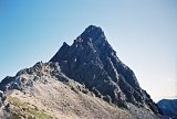
A
mandatory slight detour near the summit of Mt. Kai-koma-ga-dake
(甲斐駒ヶ岳) is its sidekick
subpeak, a large granite outcropping just below it and to the
southeast known
as Marishiten (摩利支天, from
“Marici”
in Sanskrit), named after a 3-headed, 6-armed female warrior goddess
with a
different weapon in each hand and riding on the back of a boar.
Check out the
picture of the very impressive Marishiten (摩利支天) monument
there in my photo album below.

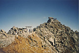
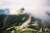
Mt. Kai-koma-ga-take (甲斐駒ヶ岳) and its subpeak,
Marishiten (摩利支天) (photo courtesy: Wikipedia)
The
trek back down to the Kitazawa-toge (北沢峠) trailhead was fairly
uneventful, albeit SO beautiful, passing Mt. Komatsumine (駒津峰)
once again as well as Mt.
Futagoyama (双
児山).
I caught the 13:10 microbus back to Hirogawara and shared a taxi back
to JR
Kofu Station. Catching an express train there around 3:30 pm allowed me
to
arrive back at JR Shinjuku Station in Tokyo by 6:30 pm.
My Mt. Senjo-ga-take (仙丈ヶ岳)
and Mt. Kai-koma-ga-dake
(甲斐駒ヶ岳)
Pics
The pics in the collage below are a sampling of my Senjo/Kai-koma photo
album hosted at Flickr. Clicking on
the collage
will open up the album on a separate page. I hope
you enjoy them !

Click here to view all of my Mt. Senjo-ga-take
(仙丈ヶ岳) and Mt. Kai-koma-ga-dake
(甲斐駒ヶ岳)
pics, taken
Aug. 12-13, 1997.
My Google Map of Mt. Senjo-ga-take
(仙丈ヶ岳) &
Mt. Kai-koma-ga-dake
(甲斐駒ヶ岳)
In Oct. 2009 I created the customized map below, as I thought it'd be
cool to see all of Japan's 25 highest mountains at a glance.
Route Map & Elevation Profile
of Mt. Senjo-ga-take (仙丈ヶ岳)
and Mt. Kai-koma-ga-dake
(甲斐駒ヶ岳)
Source: Yamareco.com
Note: I followed the above route almost exactly,
except that I climbed
Mt. Senjo-ga-take (仙丈ヶ岳) first.
Access
One of the best ways to get to JR Kofu Station (甲府駅) is to take an
Azusa or Kaiji limited express train from Shinjuku Station (新宿駅), which
only
takes
about 1.5-2 hours. More details on these trains are here. Also, there are obviously
slower and cheaper ways to get there on JR's Chuo Line. More info in
English is available from JR East at (050) 2016–1603, 10:00 to 18:00,
every day of the year except during the year-end/new year
holidays.
Bus transportation from Kofu Station is
available via Yamanashi
Kotsu (Tel:
(055) 223-0821)
(Japanese),
which will provide varying levels of service to
Hirogawara between June 23 and November 5, 2023 (depending
on the month
and day of week) for ¥1990 and the bus schedules (in Japanese) are
here: http://yamanashikotsu.co.jp/route_bus/route_sp_info/hirogawara/
[Yamanashi
Kotsu removes their bus schedules during the off-season, so I will post
a link to their 2024 schedules here next June.]
Again in 2023
it is also possible to catch a direct all-night bus from the
Shinjuku Station West Exit to Hirogawara every Friday night from June
23 to Oct. 27 plus
every Tues. night in July and August (7/4-8/29). The 22:00 pm to 6:13
am bus trip will set you back ¥8800 (no direct service is available
back to Shinjuku). More details (in Japanese) are here: http://yamanashikotsu.co.jp/travel/hirogawara/
[bus schedule links removed during the off-season]
[Please note that
due to damage to the forest road from Typhoon 19 on October 12, 2019,
the bus from Hirogawara to Kitazawa-toge will still be suspended during
the
2023 climbing season, and according to info on the Yamanashi Kotsu
website,
this road is also impassible, even by walking.]
Private cars are restricted on the road to Hirogawara, but 121 parking
spaces are available near JR
Kofu Station South Exit (JR甲府駅南口) (max. ¥900/weekdays), 172 spaces
are available near Ryuo
(竜王) Station South Exit
(max. ¥900/weekdays), and 147 spaces are available at the two Narada
(奈良田) parking areas near the Narada Onsen trailhead for Mt.
Notori-dake.
Minami Alps Mountain Huts
Reservation System
For the 3rd year, it is now possible to reserve Minami Alps mountain
huts in advance online. More details (in Japanese) are about 1/4 down
this page: http://yamanashikotsu.co.jp/route_bus/route_sp_info/hirogawara/
Historic Kofu
If you have any extra time to kill after your hike and don't need to
rush back home, I highly recommend that you soothe
your muscles in a nice hot spring
rotemburo in the Yumura Spa area, a 10-minute bus
ride from JR Kofu Station. And it'll only dent your pocketbook by
¥700 or so.
Kofu is a very historic city, known as the home of Takeda Shingen, one
of Japan's most powerful 16th-century warlords. And because about 30%
of
Japan’s carved jewelry is produced in the area, Kofu is known as
Japan's most famous jewelry city.
Kofu is also home to Hidetoshi Nakata, the world-famous soccer player
who last played in the Premier League and retired following the 2006
World Cup, and Naoko Takeuchi, creator of "Sailor Moon" and other
comics.
So if you have a few extra hours to kill in Kofu, besides the
abundant hot
springs, there are a number of fun things to see and do there,
including the Shosenkyo Gorge, Takeda-jinja Shrine
(dedicated to the
famous warlord), and the Yamanashi
Prefectural Museum of Art.
Please stop by again soon
My Aug. 12-13, 1997 climb of Mt. Senjo-ga-take (仙丈ヶ岳)
and Mt. Kai-koma-ga-dake
(甲斐駒ヶ岳) in
the Southern Japan Alps (南アルプス) was an awesome hiking trip. From these
hiking trails, the views
of the other several nearby peaks are arguably some of the
most spectacular you'll
ever see anywhere in Japan.
The only drawback about
hiking during the busy Obon holidays in Japan, though, is you
are certain to encounter crowded conditions on the trails and in
the huts. But I guess that comes with the
territory, since Hirogawara (広河原) is not
only the main access route to Mt. Kita-dake (北岳), Japan’s 2nd highest
peak,
but also the most popular base
for
climbing the magnificent Southern Japan Alps
(南アルプス).
I hope you found this page informative and do please stop by
again soon, as
I intend to update it with more
details in the future on climbing Mt. Senjo-ga-take (仙丈ヶ岳) and
the Mt. Kai-koma-ga-dake
(甲斐駒ヶ岳), including a record of my climbing schedule and
trip expenses.
In the meantime, if you have any quick questions for me, feel
free to give me a shout
by posting them in the "Add your comment" section below or by clicking
on the "Contact Me" link at the top right of this page. Or if you'd
care to
share your climbing story and pics with other climbers, feel free
to do so in the "Have a Question or Story...?" section
below.
And if you are lucky enough to
hike up either of these awesome peaks, I wish you my most heartfelt
good
luck. GO FOR IT!!
Additional links:
Mt. Senjo-ga-take (仙丈ヶ岳) summit
6-day weather forecast
Mt. Senjo-ga-take
(仙丈ヶ岳) topo
map (from the Geospatial Information Authority of Japan)
Mt. Kai-koma-ga-dake
(甲斐駒ヶ岳)
summit
6-day weather forecast
Mt.
Kai-koma-ga-dake
(甲斐駒ヶ岳)
topo
map (from the Geospatial Information Authority of Japan)
summit
6-day weather forecast
Mt. Kita-dake route map (includes
Mt. Senjo-ga-take/Mt.
Kai-koma-ga-dake) (2023 1:50,000
hiking map part of the Yama-to-kogen
Chizu
series published
by Shobunsha)
Fishing For Mountains - A very
gripping story of a spring climb of Mt.
Kai-koma-ga-dake by mountaineer extraordinaire Mr. Chris White
Have a Question or Story about Climbing Mt. Senjo-ga-take or Mt. Kai-koma-ga-dake?
Do you have a question or story about climbing Mt. Senjo-ga-take or Mt. Kai-koma-ga-dake? Be among the first to pay it forward and share your climbing experience (along with up to 4 pics) with other visitors to this page still planning their climb!
Unlike social media sites like Facebook & Twitter where your post quickly gets pushed down off the page, your story will be given a dedicated webpage and its own URL, giving others a chance to comment (you can see similar stories submitted so far on Climbing Mt. Fuji). And feel free to link your story back to your webpage, blog, or any other page of your choosing.
Back
to The Highest Mountains in Japan
|
|


New! Add your comment
Have your say about this page! Feel free to comment in the box below: