Unlike Mt. Yakushi-dake which was a real up-and-down
roller coaster ride, Mt. Kasagatake (笠ヶ岳)was basically all
an
uphill climb, but the 1800-meter elevation gain to reach the
summit was more of a workout than I'd bargained for.
Let's try to put it into a proper perspective. The 1800-meter
(5900 ft.) climb from the Shin-Hotaka Onsen (新穂高温泉) (hot spring) bus
stop
to Mt. Kasagatake's summit is equivalent to:
1) Well over a vertical mile
2) Hiking from the Colorado River at the bottom of
the Grand Canyon up to the canyon's North Rim
3) Climbing Japan's tallest skyscraper, the Landmark
Tower in Yokohama, 6 times
4) Climbing the Empire State Building in New York City over
4.5 times
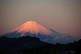
5) More than a 400-meter (~1300 ft.) higher climb than
scaling Japan's tallest mountain, Mt. Fuji, from the 5th
Station
Well, you get the picture.
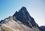
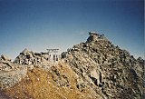
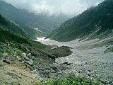
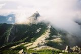
Mt.
Kasagatake (笠ヶ岳) &
Kasagatake Sanso
(笠ヶ岳山荘)
mountain hut
From Sunshine to Clouds to Mist to Sleet to Snow
The most surprising part of this climb was the snowfall that
started coming down mid-afternoon on Sat. Oct. 10, 2009 around elev.
2500m. After a big typhoon passed thru central Japan a couple
days before, I was hopeful of having some good weather for my
hike.
Wrong. Although sunny early in the day, it
proceeded to cloud up and then started misting. The mist then
turned to sleet, and then it started snowing. Wonderful.
If that weren't enough, I slipped on the snowy rocks
and sprained my ankle, which severely slowed my pace toward my
goal for the day & sleeping spot, the Kasagatake Sanso
(笠ヶ岳山荘) mountain hut.
I literally despise hiking on snow, and after it had covered not only the trail,
but also the white circle trail
markers painted on the rocks, it started to get interesting.
And when nightfall came, I was still 45 minutes from
the
mountain hut and my headlamp was virtually worthless. My
guardian
angels were definitely working overtime.
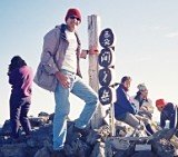
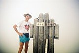
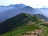
My Mt. Kasagatake (笠ヶ岳) Pics & Video
I hope you enjoy my pics & video below, hosted at
Flickr and YouTube, respectively !
The video, in particular, will give you a real feel for actually being
there, especially life inside a Japanese mountain hut.
Japan's mountain hut system is definitely convenient, eliminating the
need for a tent, sleeping bag, cook stove, or lots of food.
As a
result, most Japanese people hike with TINY packs. I haven't
quite got it
mastered, however, because with 1.5 liters of water, mine weighed in at
over 11kg. Ugh...
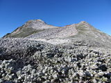
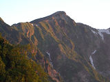
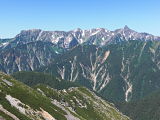
You can view here all of my Flickr pics of Mt.
Kasagatake (笠ヶ岳), elev.
2898m, Japan's
34th highest peak, taken Oct.
9-11, 2009.
Mt. Kasagatake,
elev. 2898m, Japan's 34th highest peak, Northern Japan Alps, Oct. 9-11,
2009
(If player above is not visible, you can view video
at YouTube here.)
My Google Map of Mt. Kasagatake
(笠ヶ岳)
In Oct. 2009 I created the customized map below, as I thought it'd be
cool to see all of Japan's 25 highest mountains at a glance.
Although
as Japan's 34th highest peak, Mt. Kasagatake (笠ヶ岳) is not among the
25 highest, zooming out on the map below will allow you to see all of
the 25 highest mountains in Japan.
One of the smartest
things I did before this trip was go to Tokyo's
Akihabara Electric Town and buy a $150 Casio ProTrek triple sensor
watch, which includes an altimeter,
barometer, thermometer, and digital
compass.
The most amazing thing is it records your elevation reading
automatically every 15 minutes and holds up to 50 records, meaning you
can record over 12 hours of data. As a result, I was able to track my
elevation progress both up and down Mt. Kasagatake for the entire
duration of my hiking journey.
Honestly speaking, I wasn't planning on mountain climbing this year,
and thus was seriously out of shape, but
with
the passage of Typhoon 18 on Thurs. Oct. 8 and the approaching 3-day
weekend (Mon. Oct. 12 was Sports Day, a national holiday), I decided to
go for it.
An Expensive
Trip !
There are much cheaper (albeit slower & not so convenient ways)
to get to Shin-Hotaka Onsen (新穂高温泉), but I suddenly got alpine fever
and was ready to get the heck outta Dodge....quickly. It's
terribly expensive to travel around inside of Japan, and for the same
amount
of cash I forked over for this trip (>$500),
I could've taken a nice 3-day overseas vacation to a place like
Korea or Guam.
But it was an awesome trip, nonetheless. Please stop by again soon, as
I intend to add more
details later on this Mt. Kasagatake climbing trip. As I recommended at
the end of the above
YouTube video, "Stay fit and keep hiking !"
Oh yeah, the Kasagatake Sanso (笠ヶ岳山荘) mountain hut
has a great website
(mostly in Japanese),
including up-to-date pics, trail route/access info, a live webcam, and
a blog.
Please
stop by again soon, as I intend to update this page periodically with
more details in the future. If you have any quick questions for me,
feel free to
give me a shout
by posting them in the "Add your comment" section below or by clicking
on the "Contact Me" link at the top right of this page.
And
if you've already climbed Mt. Kasagatake (笠ヶ岳) & you'd
care to
pay it forward by sharing your climbing story & pics with
other
climbers, we'd love to hear of your personal experience.
You
can share your story here.
Hi Gary, I love your site as it is so informative. On August 1st, 3 of us will be attempting to climb Mount Fuji. My husband and I are comparatively fit
Hi, I have some questions about reserving a hut on Mt. Fuji. I'll be in Tokyo a few days before climbing season and am attempting to climb on July 1st.
If you've found value on
this website,
please consider sending a donation of any amount
to help cover my web hosting expenses. I have intentionally limited ads,
have never used pop-ups, and do not collect email addresses
in order to provide visitors a pleasant, hassle-free experience. Thank
you!
(Please rest assured that when you click
the 'Donate' button,
your transaction will be encrypted and secure.
Your information is safe with PayPal,
one of the largest payment processors on the Internet.)


New! Add your comment
Have your say about this page! Feel free to comment in the box below: