 |
||||||
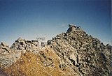
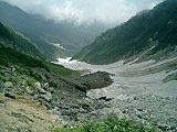
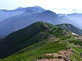
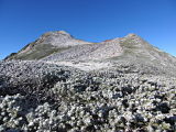
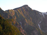
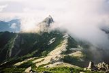
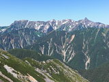
When my climbing buddy & I scaled Mt. Kashimayari-ga-dake (鹿島槍ヶ岳) in Aug. 2007, it was our 2nd attempt, having failed 2 years before. On that prior trip we encountered very severe weather (including a lightning storm) on the morning of our 2nd day of hiking, so decided pack it in (back to Tokyo). Wise decision. In fact, on that same August day in 2005 a couple of hikers died in a landslide in the Daisekkei (大雪渓) (big snow valley) enroute to the top of Mt. Shirouma-dake (白馬岳), only about 15km north of us. That abbreviated trip was a fun experience nonetheless and if you get a chance, you can check out my pics of Jii-ga-take (爺ヶ岳) and Tsumeta-ike-sanso (冷池山莊) from that trip. But this time.....WOW. Clear sunny weather....so much so in fact that it got so HOT on our 2nd day of hiking, even in those higher altitudes I suffered from a moderate case of dehydration. My hiking buddy (15 yrs. my junior) left me in the dust and I arrived at the Goryu-sanso (五竜山荘) mountain hut (late for dinner) about a half-hour behind him.  Atop Mt. Kashimayari-ga-dake (鹿島槍ヶ岳) Aug. 12, 2007 In my defense, even though this route doesn't look too intimidating on the map, from the Tsumeta-ike-sanso (冷池山莊) (elev. 2410m) where we stayed the 1st night, you gain 479m up to the summit of Kashimayari-ga-dake (鹿島槍ヶ岳), drop 419m down to the Kiretto-goya (elev. 2470m), gain 344m up to the summit of Goryu-dake (五竜岳), and then drop 324m down to the Goryu-sanso (五竜山荘) (elev. 2490m), which was only 80m higher than the day's starting point. WHEW !! This is quite a workout for anyone not in tip-top shape. We started hiking at 6:10 am and I didn't finish till 6:35 pm. Ugh !! Well, as they say, a picture's worth a thousand words, so........have a look:  Elevation profile for Mt. Kashimayari-ga-dake (鹿島槍ヶ岳), Mt. Goryu-dake (五竜岳), & Kiretto (キレット) (Source: Yamareco.com) But one of the nicest things about this hike was the way it finished.....with a nice soak in a hot spring. Hiking out the Hakuba Goryu ski valley, we were able to catch the Goryu Alps Daira Telecabin (ropeway) down to Escal Plaza in the village of Kamishiro, where we had lunch and enjoyed their onsen. From there it was a 7 1/2 hour bus ride back to Shinjuku in Tokyo. Mt. Kashimayari-ga-dake (鹿島槍ヶ岳) Pics & VideoI hope you'll have time to enjoy my pics and video shown below. The entire Flickr album of my pics of Mt. Kashimayari-ga-dake (鹿島槍ヶ岳), elev. 2889m, Japan's 36th highest peak, Aug. 11-13, 2007, can be viewed here. The video of the Kashiwara Shindo Climbing Route (柏原新道) is just 25-seconds long, but has already been circulated virally throughout cyberspace. It'll make you wish you were there. Enjoy !! Kashiwara Shindo Climbing Route (柏原新道), Northern Japan Alps (25-second panorama of the spectacular mountains from Shirouma-dake (白馬岳) in the north, to Karamatsu-dake, to Goryu-dake (五竜岳), and to Kashimayari-hoppou in the south, taken from the Tomione ridge) (If player above is not visible, you can view video @ YouTube here.) My Google Map of Mt.
Kashimayari-ga-dake
|
 A FREE download at Smashwords  Only $1.99 at Amazon (¥214 at アマゾン日本)  Only $2.99 at Amazon (¥340 at アマゾン日本)
Japan Mountain Pages:  Climbing Mt. Fuji - FAQ 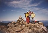 Mt. Kita-dake 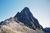 Mt. Oku-hotaka-dake & Mt. Yari-ga-take
|
|||||
|
 Only 99¢ at Amazon (¥114 at アマゾン日本)  Only $2.99 at Amazon (¥343 at アマゾン日本)  Only $2.99 at Amazon (¥343 at アマゾン日本)
What's New?
|
||||||
|
|
||||||


New! Add your comment
Have your say about this page! Feel free to comment in the box below: