 |
||||||
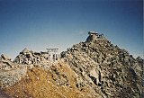
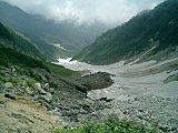
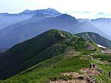
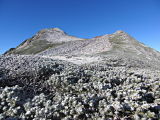
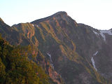
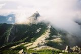
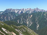
This mountain just about killed me, but Mt. Yakushi-dake (薬師岳) had without question some of the most striking vistas and panoramas I've ever seen while climbing the Japan Alps. My big mistake on the first day of hiking was trying to make it from the Murodo (室堂) Terminal trailhead all the way to the Sugo-norikoshi-goya (スゴ乗越小屋) mountain hut in one day. Although the Lonely Planet's Hiking in Japan  Murodo (室堂) Terminal trailhead As a result, I didn't arrive at the hut till around 8 pm, and because I had made advance reservations, they sent out a search party for me. Not good. Arriving late at the huts is a big breach of Japanese mountain climbing etiquette, as dinner is usually served around 5 or 6 and lights out are usually by 8. When I arrived, most people were already in their futons and lights were out, but the cordial hut staff served me dinner anyways. Roller Coaster Climbing RouteThat section of the Mt. Yakushi-dake (薬師岳) trail is one of the most up-and-down & primitive I've ever encountered in Japan, and can really take a toll on your body. From Goshiki-ga-hara-sanso (五色ヶ原山荘) you go up about 100m, down 250m, up 250m, down 300m, up 100m, down 250m, and finally up another 150m to the Sugo-norikoshi-goya (スゴ乗越小屋) mountain hut. Wow. And if that weren't enough, some of the sections are virtually vertical, requiring ascents/descents of 10-15 meters with the aid of built-in ropes and chains. As they say, "A picture's worth a thousand words," so the elevation profile on the Yamareco route map below should give you a better idea of what you're up against. My favorite passage from the Lonely Planet's description of this trail section is "So just relax and enjoy the scenery and the morning." Makes me wonder if the writer actually hiked this course.   View of Mt. Yakushi-dake (薬師岳) This trail is not very busy, and so if you have an accident you might be in deep doo-doo, as it could be ages before you get rescued, if anyone comes at all. My advice for future trekkers starting from the Murodo (室堂) trailhead & who aren't camping, is to stay overnight at the Goshiki-ga-hara-sanso (五色ヶ原山荘), where they actually have a hot bath, an extreme rarity at mountain huts in Japan. Interestingly, I had no trouble on Days 2 & 3. In fact, on Day 3 I left the Tarodaira-goya (太郎平小屋) mountain hut (where I stayed the 2nd night) before 5:30 am and was back in Tokyo by 2:30 pm via bus, local train, and shinkansen (bullet train). I finished my hiking at the Oritate (折立) bus stop. My Mt. Yakushi-dake (薬師岳) PicsI hope you enjoy my pics linked below, hosted at Flickr! It's some pretty stunning scenery, I'm sure you'll agree, and helps explain why I've lived in Japan such a loooooong time.
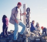
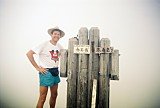
Click here to view all of my pics of Mt. Yakushi-dake (薬師岳), elev. 2926 m, Japan's 27th highest peak, taken Aug. 9-11, 2008. My Google Map of Mt. Yakushi-dake (薬師岳)In Oct. 2009 I created the
customized map below, as I thought it'd be
cool to see all of Japan's 25 highest mountains at a glance.
Although as Japan's 27th highest peak, Mt. Yakushi-dake (薬師岳) is not among the 25 highest, zooming out on the map below will allow you to see all of the 25 highest mountains in Japan. (zoom out to see all 25 highest mountains) View 25 Highest Mountains in Japan in a larger map Route Map of Mt. Yakushi-dake (薬師岳)Source: Yamareco.com (Please note: the above route map and elevation profile differ slightly from my own route, as they include an ascent of Mt. Tateyama (立山). Access
|
 A FREE download at Smashwords  Only $1.99 at Amazon (¥214 at アマゾン日本)  Only $2.99 at Amazon (¥340 at アマゾン日本)
Japan Mountain Pages:  Climbing Mt. Fuji - FAQ  Mt. Kita-dake 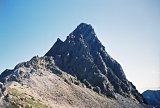 Mt. Oku-hotaka-dake & Mt. Yari-ga-take
|
|||||
|
 Only 99¢ at Amazon (¥114 at アマゾン日本)  Only $2.99 at Amazon (¥343 at アマゾン日本)  Only $2.99 at Amazon (¥343 at アマゾン日本)
What's New?
|
||||||
|
|
||||||


New! Add your comment
Have your say about this page! Feel free to comment in the box below: