 |
||||||
I did it! I can't believe I FINALLY did it. Well, I THOUGHT I did it. Oops. After over 19 years of chipping away at my list of the highest mountains in Japan, with the ascent of Mt. Jonen-dake on August 22, 2010, I thought I had finally climbed all of Japan's 25 highest peaks. Problem is.....because my list is written in Japanese (not my forte), as it turned out, my list was actually a ranking of the highest Nihon Hyakumeizan (日本百名山, Japan's 100 Famous Mountains). OMG! Mt. Jonen-dake, elev. 2857 m, is not Japan's 25th highest mountain (according to my old list), but in fact its 45th highest. How embarrassing!  But it turned out to be an awesome climbing trip nonetheless.
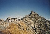
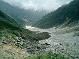
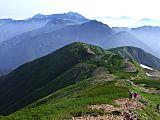
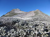
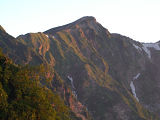
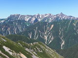
By far the highlight of this mountain climbing trip was the absolutely breathtaking view of Mt. Yari-ga-take (槍ヶ岳), Japan's 5th highest mountain, and the Hotaka mountain range, including Mt. Mae-hotaka-dake (前穂高岳), Mt. Oku-hotaka-dake (奥穂高岳), Japan's 3rd highest mountain, Mt. Karasawa-dake (涸沢岳), and Mt. Kita-hotaka-dake (北穂高岳).  Hotaka mountain range, including Mt. Oku-hotaka-dake (奥穂高岳) & Mt. Yari-ga-take (槍ヶ岳), the sharp pointy peak on the right, nicknamed the Matterhorn of Japan To be honest, in my 19 years of hiking in Japan's mountains, I don't recall ever seeing such a stunningly beautiful view of Japanese peaks anywhere, anytime. Thank God for such gorgeous weather! Friendly Japanese mountain climbersOne of the things I enjoyed the most about this hike were the many very friendly and talkative Japanese hikers of all ages who were happy to see the only foreigner on the trail (you may be amused by our lively exchange of greetings in my video below, starting at about the 2:48 min. mark). Sorry for my poor Japanese. Ichinosawa (一ノ沢) ValleyAnother thing I enjoyed about this hike was the stunning beauty of the Ichinosawa mountain stream (一ノ沢), which gave me a very pleasant cool feeling and a welcome respite from the scorched earth 35° C (95° F) days of Tokyo and the hottest August ever in that concrete jungle. Tokyo's monthly mean temperature in August 2010 was 29.6°C (85.3° F), surpassing the 29.4° C (84.9° F) previous record set in August 1995 and becoming the hottest month ever in Tokyo.  Ichinosawa mountain stream (一ノ沢) The beauty of hiking up the Ichinosawa (一ノ沢) Valley was that the tree line is just below the Jonen-goya mountain hut (常念小屋), so you are in the forest and virtually protected from the elements (sun, wind, etc.) for most of the hike. My Mt. Jonen-dake (常念岳) Pics & VideoI hope you enjoy my pics & video below, hosted at Flickr and YouTube, respectively ! The video, in particular, will give you a real feel for what it's like to hike on a Japanese mountain trail. After all these years of trekking in the Japanese Alps, I still can't get over the amazing cordiality of Japanese mountain climbers. My pics of Mt.
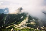
Jonen-dake (常念岳), elev.
2857m, Japan's
45th highest peak, Aug. 22, 2010 can be viewed here. My Video of Mt. Jonen-dake (常念岳), elev. 2857m, Japan's 45th highest peak, Aug. 22, 2010 (My exchange of greetings with some very lively Japanese hikers starts around the 2:45 min. mark.) (If player above is not visible, you can view video at YouTube here.) My Google Map of Mt. Jonen-dake (常念岳)In Oct. 2009 I created the customized map below, as I thought it'd be cool to see all of Japan's 25 highest mountains at a glance. Although as Japan's 45th highest peak, Mt. Jonen-dake (常念岳) is not among the 25 highest, zooming out on the map below will allow you to see all of the 25 highest mountains in Japan. Mt. Jonen-dake (常念岳) Route DescriptionFrom the Ichinosawa trailhead (一ノ沢登山口), where you'll find the mountain climbing registration office, toilets, and water, the trail follows the beautiful Ichinosawa mountain stream (一ノ沢) which you will cross a few times on your way up. The route gradually gets more narrow, and from "Last Water," your last chance to fill up your water bottles, the switchbacking trail gets quite steep up to the ridge where you'll see the Jonen-goya mountain hut (常念小屋). Behind the hut, the very striking view of Mt. Yari-ga-take and the entire Hotaka mountain range creates an adrenalin rush that all mountain climbers live (and die) for. This amazing sight was one of the most exhilirating mountain climbing sensations I think I've ever experienced. If you're blessed with nice weather as I was, you should allow yourself enough time at the summit, as this is without question one of the most spectacular, breathtaking views you'll ever see in the Japanese mountains anywhere in the country. It took me about 3.5 hours to the Jonen-goya mountain hut (常念小屋), and another hour & 15 min. up a rather steep climb to the Mt. Jonen-dake summit. The total elevation gain for this hike is around 1600 m, so it's not exactly a Sunday stroll in the park. But for a person in reasonable physical condition, it can be easily done as a day hike. I left the Ichinosawa trailhead (一ノ沢登山口) at 5:00 a.m., arrived at the Mt. Jonen-dake summit at 10:15, and finished my hike back at the Ichinosawa trailhead at 4:15 pm. I rested for 25 min. at the Jonen-goya mountain hut (常念小屋) for a cold drink on the way up, spent 20 min. at the summit of Mt. Jonen-dake, and stopped for 45 min. at Jonen-goya again on the way down to enjoy a mabo-meshi (麻婆飯, spicy Chinese chili sauce on rice) lunch.  Jonen-goya mountain hut (常念小屋) The Jonen-goya mountain hut (常念小屋) was clean, well-run, and as is always the case in Japan, staffed by very friendly people, many of them college students. This hut is part of a network of 44 mountain huts in this area run by the Northern Japan Alps Mountain Hut Friendship Association. A not-so-recent English map of these Northern Japan Alps mountain huts can be found here (Google map in Japanese here (scroll down toward the bottom of the page)), along with a not-so-recent listing of these huts with phone numbers & URLs. But telephone numbers, prices, and 2018 opening dates for the Kamikochi area mountain huts are shown on my Mt-Oku-hotaka-dake & Mt. Yari-ga-take page. If you'd like more details of my hiking trip, you might be interested in my Mt. Jonen-dake hiking schedule and elevation profile, including % grade calculations for the various trail sections, which I've compiled on a separate page. AccessI would have to say that Mt. Jonen-dake was one of the easiest and most accessible of all the highpoints in the Northern Japan Alps. From Tokyo it only takes about four hours by train or car to reach Hotaka Station (穂高駅) on the JR Oito Line (JR大糸線), the nearest station to Mt. Jonen-dake. And from Hotaka Station (or Toyoshina Station (豊科駅), which is 2 train stops closer to Tokyo), it only takes about 45 minutes by car or taxi to reach the Ichinosawa trailhead (一ノ沢登山口). Y'all come back now, ya hear?Mt. Jonen-dake was an awesome mountain climbing trip. Thank you very much for visiting this page, and if you by chance have already had the pleasure of climbing Mt. Jonen-dake, by all means I hope you will take a few minutes to share your story below with future climbers. Please stop by again soon, as I intend to add more details later on this Mt. Jonen-dake climbing trip, including a section on Japanese alpine flowers & a couple more route maps. If you have any questions, comments, or would care to share your climbing story, feel free to use the section below. Or if you prefer sending me a private message, just click on "Contact Me." And as I recommended at the end of the above YouTube video, "Stay fit and keep hiking!" Additional links:Mt. Jonen-dake summit 6-day weather forecastMt. Jonen-dake topo map (from Geospatial Information Authority of Japan) Mt. Oku-Hotaka-dake/Mt. Yari-ga-take route map (includes Mt. Jonen-dake (常念岳)) (2023 1:50,000 hiking map, part of the Yama-to-kogen Chizu series published by Shobunsha, available in bookstores and from Amazon Japan) Kita Alps area mountain hut map List of Kita Alps area mountain huts with phone numbers, prices, and 2018 opening dates Have a Question or Story about Climbing Mt. Jonen-dake?Do you have a question or story about climbing Mt. Jonen-dake? Be among the first to pay it forward and share your climbing experience (along with up to 4 pics) with other visitors to this page still planning their climb! What Other Mt. Jonen-dake Climbers Have SaidClick below to see contributions from other Mt. Jonen-dake climbers...
What's the temperature like in October on the peak of Mt. Jonen-dake??
How do I find Jonen-dake's Ichinosawa trailhead?
We would like to do a climb, thinking Mount Jonen-dake
My wife and I want to climb Mt. Jonen-dake at the end of April
How do you climb Mt. Jonen from Kamikochi?
Jonendake: Ichinosawa Transportation
I'm planning to spend 2-3 days hiking in Japan
I'm thinking of starting with Jonen-dake and then heading toward Yari-ga-take Not rated yet
|
 A FREE download at Smashwords  Only $1.99 at Amazon (¥214 at アマゾン日本)  Only $2.99 at Amazon (¥340 at アマゾン日本)
Japan Mountain Pages:  Climbing Mt. Fuji - FAQ 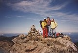 Mt. Kita-dake 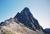 Mt. Oku-hotaka-dake & Mt. Yari-ga-take
|
|||||
 Only 99¢ from Amazon (¥114 at アマゾン日本)  Only $2.99 at Amazon (¥343 at アマゾン日本)  Only $2.99 at Amazon (¥343 at アマゾン日本) What's New?
|
||||||
|
|
||||||


New! Add your comment
Have your say about this page! Feel free to comment in the box below: