Mt. Tateyama (立山) & Mt. Tsurugi-dake (剱岳)
Got a question or story
about climbing
Mt. Tateyama or Mt. Tsurugi-dake?
|
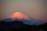
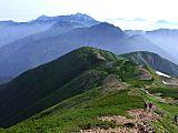
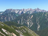
Mt. Tateyama (立山), elev. 3015 m, and Mt. Tsurugi-dake (剱岳), elev. 2999
m, are without question two of
the most
spectacular mountains in the Northern Japan Alps, if not in all of
Japan. Since the 20th
& 22nd
highest mountains in Japan, respectively,
are fairly close to each other, they are usually
climbed together and like Mt.
Shirouma-dake can be easily done in a
weekend.
This is what I did, actually, leaving on a Friday night from Shinjuku,
Tokyo, via the Alpico
highway bus and returning
back to Tokyo late on a
Sunday
night.
The 1-way bus fare from Shinjuku to Murodo set me back ¥13,000.
OUCH!  [By comparison, local
travel agencies routinely advertise round trip airfares to Korea for
less than ¥10,000.] [By comparison, local
travel agencies routinely advertise round trip airfares to Korea for
less than ¥10,000.]
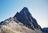
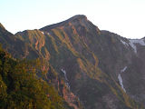
By far the most exhilarating part of this journey was the last 200 m or
so before reaching the summit of Mt. Tsurugi-dake. Chains, ropes,
ladders, and even built-in metal staircases were the
order of the day along this route, but the most hair-raising spots were
the two so-called “crab”
sections.
The first exciting crab section is
called “kani-no-yokobai” (see pic
below), which in Japanese means crawling sideways like a crab. The
other one, as you have probably already guessed, is called
“kani-no-tatebai,” meaning crawling upwards like a crab, a pic of which
is in my Flickr photo album linked below.
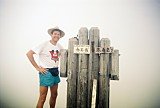
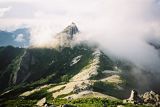
") Kani-no-yokobai
(crawling sideways like a crab),
Kani-no-yokobai
(crawling sideways like a crab),
near the summit of Mt. Tsurugi-dake (剱岳)
I must admit that it wasn’t nearly as scary as it looks, but let’s be
clear, it’s not a place for mistakes, so if you slip and fall, there’s
a very good chance you’ll meet your maker.
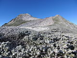
In
addition to my primary targets for this trip....the Tateyama
twin peaks
of Oyama (雄山, elev. 3003 m) &
Onanji-yama (大汝山, Tateyama's highpoint) and Mt.
Tsurugi-dake....2 other
Japan highpoints along this route worthy of mention are Mt.
Bessan (別山, elev. 2880 m) & Mt. Masago-dake (真砂岳,
elev. 2861 m), the
37th & 43rd highest mountains in Japan, respectively.
Mt. Tateyama (立山) & Mt.
Tsurugi-dake (剱岳)
Pics
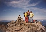
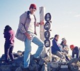
 Atop Mt.
Tsurugi-dake (剱岳),
Atop Mt.
Tsurugi-dake (剱岳),
elev. 2999 m, Japan's 22nd highest mountain
(view entire
Mt.
Tateyama (立山) Flickr album here)
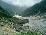
One of the things that I like best about the hikes from the Murodo (室堂)
bus
terminal is the breathtaking vistas one can see in the Murodo Valley
and throughout the Tateyama range, including a great view of Lake
Kurobe, which you can see in the photo album below. I also climbed Mt. Yakushi-dake
starting from Murodo (室堂).
I hope you'll have time to check out the pics in my Flickr
photo album of this fabulous mountain climbing trip. I have a feeling
you're gonna agree with me
about the gorgeous scenery I saw. No disrespect to my own home country,
but we don't have anything even close to this in Texas, which may help
explain why I've lived in Japan SOOOOOO long.
Click here to view my entire
album of Mt.
Tateyama (立山) & Mt. Tsurugi-dake (剱岳), Japan's 20th
& 22nd
highest peaks, respectively, taken Oct. 5-7,
2001. Enjoy!!
My Google Map of Mt. Tateyama (立山) &
Mt.
Tsurugi-dake (剱岳)
In Oct. 2009 I created the customized map below, as I thought it'd be
cool to see all of Japan's 25 highest mountains at a glance.
(zoom out to see all 25 highest
mountains)
View 25 Highest
Mountains in Japan in a larger map
Note: The highest point of the Tateyama peaks is called Onanji-yama
(大汝山).
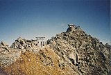
Route Map of Mt. Tateyama (立山) &
Mt.
Tsurugi-dake (剱岳)
Source: Yamareco.com
(Mouse over graph to see elevations & place names.)
Transport from Hell
The only mistake I made on this trip was to take it on the three-day
Sports Day weekend in early October. The hiking trails and mountain hut
where I stayed, Kenzan-so (open late June to Oct. 10), were
not so crowded, but the transport
services along the Tateyama Kurobe Alpine Route on
that
Sunday when I
left were CRAZY.
The first segment from Murodo (室堂), the tunnel trolley bus, was no
problem.
In fact I was able to hop on it at 3:15 p.m., only 10 minutes after I
finished hiking. But in Daikanbo, I lost over 2 hours waiting for the
Tateyama cable car due to the holiday crowds. As a result, when I
finally got back to Shinano-Omachi Station (信濃大町駅), it was too late to
catch
a
train back to Tokyo.
Fortunately, a Japanese guy at the station suggested we share a nearly
one-hour taxi ride
over to Nagano Station, where we could catch a shinkansen bullet train
back to Tokyo. Although this turned out to be a tad pricey, the payoff
was that I was able
to reach Tokyo
Station by 11 p.m. and sleep in my own bed that night.
Note: Alpico no longer provides the Shinjuku to Murodo bus service, but
you can take their highway bus from Shinjuku to Ogizawa (¥4850 1-way,
¥8700
round trip---it's more expensive for the all-night bus) (http://sawayaka.alpico.co.jp/area/hakuba/shinjuku/),
and then catch a couple of tunnel trolley buses, a cable car, and a
ropeway
along the Tateyama Kurobe Alpine Route over to Murodo (¥5860 1-way,
¥9050
round trip) (http://www.alpen-route.com/en/transportation/timetable-fares).
Keeping
track of these constantly evolving transport services from year to year
is quite challenging, and it's quite possible there may be easier &
cheaper ways to access these peaks, and if
so, please feel free to educate me & I'll update this page for the
benefit of future site visitors.
Sayonara!
Well, I guess that’s enough for now. Thank you so much for visiting my
website. Please come back again soon as I intend to add more data in
the future. In the meantime, you may wish to check out my Mt.
Tateyama (立山) & Mt. Tsurugi-dake (剱岳) schedule &
expenses page.
If you're the high-tech type, you can subscribe to my RSS feed and that
way you’ll know
when this page is updated. If you have any quick
questions, feel free to give me a holler. Just click on "Contact Me."
Or if you have a more significant question, comment, or story, I hope
you'll be kind enough to
share it in the special section below.
Ciao!
Additional links:
Mt. Tateyama summit 6-day weather
forecast
Mt. Tsurugi-dake summit 6-day
weather
forecast
Mt. Tateyama topo map (from the
Geospatial Information Authority of Japan)
Mt. Tsurugi-dake topo map (from
the Geospatial Information Authority of Japan)
Mt. Tateyama/Mt.
Tsurugi-dake
route map (2023 1:50,000 hiking map, part of the Yama-to-kogen Chizu
series published
by Shobunsha, available in bookstores and from Amazon Japan)
Tateyama live web cam (updated hourly from 6 am to
6 pm)
Have a Question or Story about Climbing Mt. Tateyama or Mt. Tsurugi-dake?
Do you have a question or story about climbing Mt. Tateyama or Mt. Tsurugi-dake? Be among the first to pay it forward and share your climbing experience (along with up to 4 pics) with other visitors to this page still planning their climb!
Unlike social media sites like Facebook & Twitter where your post quickly gets pushed down off the page, your story will be given a dedicated webpage and its own URL, giving others a chance to comment (you can see similar stories below submitted so far on climbing Mt. Tateyama & Mt. Tsurugi-dake). And feel free to link your story back to your webpage, blog, or any other page of your choosing.
What Other Mt. Tateyama and Mt. Tsurugi-dake Climbers Have Said
Click below to see contributions from other Mt. Tateyama and Mt. Tsurugi-dake climbers...
Back
to The Highest Mountains in Japan
|
|


New! Add your comment
Have your say about this page! Feel free to comment in the box below: