 |
||||||||
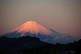
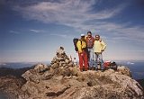
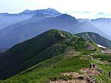
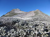
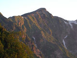
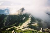
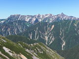
Mt. Kita-dake, Japan's second-highest mountain, is one of the Shiranesanzan (白根三山, "3 white summits"), along with Mt. Ai-no-dake, and Mt. Notori-dake. Mt. Kita-dake is not only the tallest mountain in the Southern Japan Alps, but is also one of the 100 Famous Japanese Mountains (日本百名山, Nihon Hyaku-meizan). It is also the only one of Japan's 25 highest mountains that I have climbed 3 times. The first time was October 1-3, 1993 (this page), when I went with one of my fellow English teaching friends from Canada, Mr. Mike Hodges, and one of my English students, Takahashi-san. The 2nd time was when I climbed Mt. Ai-no-dake (間ノ岳) and Mt. Shiomi-dake (塩見岳) in Sept. 1996 and the 3rd time was when I climbed Mt. Notori-dake (農鳥岳) and the Shiranesanzan (白根三山) in Aug. 2011. Mt. Kita-dake (北岳) is one of Japan's highest mountains that you can do in a weekend from Tokyo. In fact, I worked till 9 PM on that Friday night and we were back in Tokyo by Sunday night. Because we got a late start on Friday night, we didn't arrive at Kofu Station till after midnight, and then shared a taxi up to the Hirogawara (広河原) trailhead. So on Saturday morning we got a nice early start shortly after daybreak.  Atop Mt. Kita-dake (北岳) with Mike Hodges and Takahashi-san Mt. Kita-dake (北岳) Route DescriptionAbout 20 minutes down the trail from the Hirogawara (広河原) trailhead, you have a choice of two routes, so you can do the up-and-down course in a loop. But both of the mountain huts, Shirane-oike-koya (白根御池小屋) and Kata-no-koya (肩ノ小屋), are on the right-hand trail, so at the fork we chose to go up the left-hand trail, which follows the Okabasawa (大樺沢) mountain stream in the direction of Futamata (二俣) and Happonba-no-koru (八本歯のコル), so we'd reach our sleeping spot on the way back down. Another good place to stay, if you're headed south to peaks like Mt. Ai-no-dake and Mt. Shiromi-dake is the Kita-dake-sanso mountain hut (北岳山荘), but it's a little out of your way if you're just making the loop route I'm describing on this page. One of the beauties of hiking in the Japanese Alps is there are plenty of built-in ladders, chains, ropes, and even stairs to assist your climbing. And Mt. Kita-dake is no exception….there are numerous ladders, as you can see in my photo album below. We were blessed with great weather that weekend, and one bonus was the breathtaking view of Mt. Fuji from the summit of Mt. Kita-dake. Some of my favorite pics from the trip were those of us atop Japan's second-highest mountain, with a view of Japan's highest mountain in the background. Awesome!  Atop Mt. Kita-dake, Japan's 2nd highest mountain, with Mt. Fuji, Japan's highest, in the background It was so clear that day that we could also see all the way to the Kita Alps, as well as Yatsu-ga-take to the east. After a nice relaxing lunch and enjoying the breathtaking views, we then hiked down first to the Kata-no-koya mountain hut (肩ノ小屋), where we stopped briefly to wet our whistles with a cold drink, then continued down to the Shirane-oike-koya mountain hut (白根御池小屋) where we spent the night. Takahashi-san camped in his tent while Mike and I stayed in the hut. I believe that set us back around ¥8000 each, including dinner and breakfast. Our two-hour hike back down to Hirogawara (広河原) the next morning was very pleasant, where we crossed a number of beautiful tributaries and their waterfalls of the Okabasawa (大樺沢) mountain stream, and we were blessed with yet another gorgeous day. Depending upon which trail map you consult, which route you choose (right side or left side), and whether you have to contend with any snow, from the Hirogawara trailhead to the summit of Mt. Kita-dake, it should take you between 6-8 hours up and 3-5 hours down. The net elevation gain is around 1700m, as compared to the approximate 1500m required to climb Mt. Fuji on the main Kawaguchiko trail from the fifth station. My Mt. Kita-dake (北岳) PicsMy pics below are hosted at Flickr. Clicking on the thumbnail collage will open up my photo album at Flickr on a separate page. I hope you enjoy them!  You can view here all of my pics of Mt. Kita-dake, taken Oct. 2-3, 1993. My Google Map of Mt. Kita-dake (北岳)In Oct. 2009 I created the customized map below, as I thought it'd be cool to see all of Japan's 25 highest mountains at a glance. Route Map & Elevation Profile
|
||||||||


Postscript sidebar:
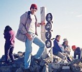
Any references to Mt. Kita-dake's elevation as 3192m are outdated and
inaccurate. In 2004, Japan's Geospatial Information Authority
(equivalent to America's USGS) revised Mt. Kita-dake's elevation 1m
higher
to 3193m, and in July 2006, a 19-person team installed Mt. Kita-dake's
new summit triangulation marker. Mt. Kita-dake's summit sign showing its new elevation (photo taken Aug. 12, 2011) |
Back to The Highest Mountains in Japan

A FREE download at Smashwords

Only $1.99 at Amazon
(¥214 at アマゾン日本)

Only $2.99 at Amazon
(¥340 at アマゾン日本)

Japan Mountain Pages:
Climbing Mt. Fuji - FAQ
Mt. Kita-dake
Mt. Oku-hotaka-dake
& Mt. Yari-ga-take
Mt. Ai-no-dake &
Mt. Shiomi-dake
Mt. Warusawa-dake
& Mt. Akaishi-dake
Mt. Tateyama &
Mt. Tsurugi-dake
Mt. Shirouma-dake
Mt. Yakushi-dake
Mt. Kasagatake
Mt. Kashimayari-ga-dake
Mt. Suisho-dake &
Mt. Washiba-dake
Mt. Jonen-dake

Only 99¢ from Amazon
(¥114 at アマゾン日本)

Only $2.99 at Amazon
(¥343 at アマゾン日本)

Only $2.99 at Amazon
(¥343 at アマゾン日本)
What's New?
-
How much time does it take from the Mt. Fuji Yoshida Trail to the Kengamine Peak?
Apr 26, 24 11:01 PM
Hi Gary, I love your site as it is so informative. On August 1st, 3 of us will be attempting to climb Mount Fuji. My husband and I are comparatively fit -
How hard is it to get a Mt. Fuji mountain hut reservation at a higher elevation station?
Apr 26, 24 10:32 PM
Hi, I have some questions about reserving a hut on Mt. Fuji. I'll be in Tokyo a few days before climbing season and am attempting to climb on July 1st. -
25 Ways the U.S. is Being Destroyed
Apr 24, 24 09:00 AM
A Warning to America: 25 Ways the U.S. is Being Destroyed | Explained in Under 2 Minutes (click link to view shocking video)
New! Add your comment
Have your say about this page! Feel free to comment in the box below: